| (A)
Prologue |
|
BATFISH arrived Midway from Third War Patrol on 8 July, 1944. Sixteen day refit by U.S.S. PROTEUS. Sound tested on 24 July. Three day's training during which time fired 8 exercise torpedoes including 4 Mark 18 from after tubes.
Ready for sea 1 August. |
| (B)
Narrative |
| 1530(Y) |
Underway from Submarine basin, Midway, for patrol area. Air coverage by two planes of Marine Air Group 23 until 1830(Y). |
| 1706(Y) |
Sighted periscope bearing 327° T, distant 1000 yards. Turned away at flank speed and sent contact report to air escorts, as well as to operational command at Midway. The position of this submarine was 15 miles bearing 236° T from Midway. |
| 1 August - 12 August |
|
Enroute patrol area. Conducting daily training dives, ship and fire control drills enroute. |
| 4 August |
| 1512(L) |
Sighted a barnacle encrusted mine floating in Lat. 25°-43'N., Long. 171°-44'E. which we sank with 20 MM fire. Mine did not explode. |
| 5 August |
| 1500(L) |
Sighted unidentified submarine on surface on an easterly course. (Ship contact #1) The initial contact was made through the high periscope so turned to close, and when range was 15,000 yards, dove in order to investigate him unobserved.
Could not see him at 50 feet so planed up to 25 feet only to discover that he had dived also. Therefore, after playing hide and seek for an hour and a half, at |
| 1647(L) |
Surfaced and zig zagged radically around in
the vicinity at flank speed. Sent contact report to Comsubpac. |
| 1830(L) |
Unable to regain contact and since it's a big ocean out here, and this is
like looking for a needle in a haystack, gave up the search and continued on toward our area. A surfaced submarine or for that matter a submerged submarine is not very adaptable for hunting down another submarine which is submerged and which was 7 1/2 miles away when last seen.
All times hereafter are (-9) unless otherwise noted. |
| 10 August |
| 0855 |
SD contact (Plane contact #1) at 15 miles, closed to 11. Dove. |
| 0900 |
One bomb - not close. |
| 0907 |
Sighted 2 engine patrol bomber
in periscope directly overhead. |
| 0953 |
Surfaced. SD contacts at 18 miles and at 2 miles. Dove. (Ed note: I doubt the one at 2 miles, but the radar operator sticks by his guns.) |
| 1057 |
Surfaced. All clear. |
| 11 August |
| 0833 |
SD contact 19 miles. (Plane contact #2) |
| 0834 |
Another plane at 7 miles. Sighted by O.O.D. bearing 330° T and headed directly for us. Dove. Since we are only 450 miles from Saipan, these two planes are probably friendly patrols. |
| 1300 |
Sighted a two engine
patrol bomber from the bridge distant about 9 miles. (Plane contact #3). Dove. |
| 1405 |
Surfaced. |
| 1610 |
Sighted submarine through the high periscope about 14,000 yards on port beam. Turned to get in position on his track and well ahead. (Ship contact #2). |
| 1624 |
Submarine changed course to south and dove. Although he was never positively identified, I was reasonably sure at the time that he was the BALAO. However, later intelligence as to the BALAO's whereabouts contradicts this, so now I don't know. This is the second time this situation has come up and each time I've closed too much while trying to get ahead of him and on his track in order to dive, identify him undetected, and fire either torpedoes or smoke bombs. Next time we will stay out of sight and use a OUIJA board. |
| 1637 |
Changed course to 190 and ran full speed for two hours. |
| 1850 |
SJ radar interference on port quarter. May be our erstwhile friend. Keyed the recognition signal over the SJ but received no answer. |
| 12 August |
| 1129 |
Sighed MAVIS coming out of cloud bank directly overhead. (Plane contact #4). Dove and held our breath for about two minutes, but no bombs. |
| 1318 |
Surfaced. |
| 13 August |
| 0100 |
Entered area. Patrolling to southward at 3 engine speed. |
| 0527 |
Dove. |
| 0627 |
Surfaced. |
| 1300 |
Sighted unidentified plane at about 10 miles. (Plane contact #5) Dove. Since we are about 10 miles east of NGARUANGL PASSAGE and PALAU is visible through high periscope, decided to make submerged patrol during rest of afternoon and utilize the time for rotating Mark 18 Torpedoes aft. |
| 1603 |
Sighed 3 SALLIES at about 3 miles crossing ahead on westerly course. (Plane contact #6). |
| 1837 |
Surfaced. Continued patrolling to southward. |
| 2012 |
Tracked a rain squall that gave a beautiful pip at 8400 yards.
Visions of getting a ship the first day in the a area faded into disappointment, as the pip faded into nothing. |
| 2153 |
Single Liberator dropped four bombs on northern airstrip at BABELTHUAP. No fires and no flak as far as we could tell. |
| 2210 |
Searchlight display from southern end of island which appeared ragged and as if operators were confused. |
| 2228 |
Second plane dropped his bombs with same results. |
| 14 August |
| 0510 |
Dove. Went to 300 feet for BT card and commenced submerged patrol off YOO CHANNEL, KORROR
ROAD and GOPAKLBAD PASS. Intermittent heavy rain squalls impaired visibility considerably at intervals during the day. |
| 1850 |
Surfaced. Commenced patrolling along YOO - YAP route. |
| 2044 |
Received orders changing patrol areas. Changed course to pass to southward of ANGUAR. |
| 2255 |
One Liberator dropped eight bombs in locality of southern airfield on BABELTHAUP IS. No fires observed, no apparent counter measures. |
| 15 August |
| 0521 |
Dove. |
| 0941 |
Surfaced. Patrolling to westward along PALAU - DAVAO route. |
| 1600 |
Changed course to 080. |
| 16 August |
| 0100 |
Patrolling off PALAU to northward along route to EMPIRE. |
| 0518 |
Dove. Went to 310 feet for BT card. No temperature gradient. Submerged patrol north and south off
AIWOKAKO and TOAGKL MLUNGUI passages. Sighted no planes, no patrols, and no shipping in the harbor. This place is uncommonly quiet, although the lack of activity may be significant, in that it indicates that no ships are due in the immediate future. With this in mind at |
| 1852 |
Surfaced and patrolled to the northward along PALAU - EMPIRE route. |
| 17 August |
| 0000 |
Shifted patrol line to PALAU - FORMOSA route. |
| 1100 |
Changed course to intercept any traffic between San Bernadino Straights and PALAU. |
| 18 August |
| 0520 |
Dove for trim. |
| 0614 |
Surfaced. |
| 0930 |
Received HARDHEADS dispatch concerning damaged battleship and decided to patrol along track to westward in hopes of intercepting anything they missed. |
| 1030 |
Received Comsubpac's dispatch re- damaged battleship, and since we are only 125 miles from point of the attack went ahead full to try and make contact. |
| 1100 |
Tried to raise HARDHEAD on area frequency to tell them we were heading into their area. No
response, so sent it blind twice and then attempted to raise NPM. No answer on either 8470 or 16490. |
| 1800 |
On the "spot" but nothing in sight except lots of ocean, lots of sky, and a few boatswain birds. Commenced a search to the west and south. |
| 2048 |
Intercepted HARDHEAD's amplifying report and, since it looks like her attacks were effectively lethal, changed course to head back toward our area and at the same time patrol across the EMPIRE - HALMAHERA route. |
| 19 August |
| 0532 |
Dove. |
| 0857 |
Surfaced. |
| 2038 |
Turned east to patrol across FORMOSA - PALAU route. |
| 20 August |
| 0525 |
Dove. |
| 0904 |
Surfaced. Patrolling to eastward across OKINAWA JIMA - PALAU line. |
| 1029 |
A "BETTY" popped out of the clouds about 3 miles astern crossing our track from starboard to port. (Plane contact #7). Dove with our fingers in our ears. Apparently he didn't see us so decided to hang around in the vicinity for a while in hopes that he was scouting ahead
of a few targets coming our way - no luck. |
| 1202 |
Surfaced. |
| 1600 |
Changed course to 120 to head for TOAGKL MLUNGUI PASS. |
| 21 August |
| 0100 |
Changed course to head for PELELIU ISLAND. |
| 0108 |
SJ phantoms. |
| 0349 |
More phantoms, turned out to be birds and we were able to track them out to a range of 2500 yards. Very disturbing to say the least. |
| 0515 |
Dove for submerged patrol to westward of PELELIU and ANGUAR ISLANDS. |
| 1903 |
Surfaced. |
| 2030 |
Received plane's contact report re- destroyer aground on VELASCO Reef. Headed north to investigate. |
| 23 August |
| 0514 |
Dove on course 120. Proceeding around northern end of VELASCO Reef. |
| 0850 |
Sighted smoke bearing 206° True. |
| 0903 |
Surfaced and attempted to close at full speed. SD contact at 18 miles, closed to 14 and disappeared. (Plane contact
#8) |
| 0930 |
SD contacts at 15 miles and at 9 miles. (Plane contact #9) Plane at 9 miles closed to 7 so at |
| 0932 |
Dove and continued closing smoke submerged. this smoke was coming from direction of NGARUANGL Reef and I figured it was from tugs who were working on the beached destroyer. |
| 1142 |
Sighted ship, MFM, bearing 270° True, range 12,000 yards. Commenced approach and since ship tracked at zero speed I figured it was aground or anchored. |
| 1201 |
Sighted mast bearing 266° T and several sources of smoke in same general direction. |
| 1303 |
With range to target 5000 yards an entirely new picture appeared over the horizon. Successive cuts had shown our target to be on the northeastern part of the reef where HO Conf. Chart 6074 shows a sand bar. Target is an AK of about 3000 tons and since she is high and dry it is impossible to get to her with a torpedo. A mine layer is anchored inside the 10 fathom curve of VELASCO REEF, just to eastward of the AK. A small auxiliary powered boat is running between the AK and the CM, either unloading stores or engaged in some kind of salvage work. A MINEKAZE class DD is either anchored or underway and stopped one mile south of NGARUANGL ISLAND. A FUBUKI class DD is aground on western most edge of NGARUANGL REEF. Two sea going tugs (these were the smokers), two PC type and a sampan type patrol boat are underway
and patrolling in vicinity of the beached destroyer. Two planes, a fighter and a bomber are patrolling over the whole outfit which I shall call the VELASCO REEF TASK FORCE. Another plane, 2 engine, is on the water near NGARUANGL ISLAND, apparently tied to a buoy. An estimate of the situation showed the MINEKAZE to be our target of the moment, and the AK to be out of
reach of torpedoes, but a possible target for the 4 inch gun at a later date when he doesn't have so much protection. The beached DD is an unknown quantity since he is across the reef and I can't tell just how he is situated. Broke off approach on
AK and started after the MINEKAZE DD and incidentally spent a lot of time familiarizing myself with the navigation in NGARUANGL PASSAGE for future reference. (Plane contact #10 - Ship contact #3) |
| 1402 |
Fired tubes 1, 2, and 3 on a 53 port track at range of 2670 yards, aimed at bow, MOT and stern by periscope. 3 hits. Torpedoes were set for 5 feet and smoked excessively. Sea calm, no wind. |
| 1404 |
Changed course to left to pull out and head around to other side of reef. Target sinking with a
port list, water up to bridge, smoking heavily. |
| 1405 |
PC boat headed our way so went deep and rigged for silent running. Reef noises all around were so loud it was impossible to hear screws. |
| 1447 |
At periscope depth. A PC had moved over between us and the AK and seemed very confused. The CM was getting up steam, the FUBUKI DD didn't seem to be doing anything, a float type plane had joined the bomber, the PC and the sampan screen had moved in close, and our first target has disappeared. Looks like the VELASCO REEF task force was caught with their pants down and don't know what to do about it. Decided to go back and get a quick look at the AK as close as we can, just to make sure he's not for us. Reef noises are so loud I doubt if the screens would know they had us even if they did. |
| 1538 |
With range to AK about 2000 yards and BATFISH practically aground, saw that it
would be futile to attempt to get a torpedo into this ship. The reef is breaking 50 feet from him ahead and on both sides and to hit him would
necessitate navigating inside VELASCO REEF and since he is a good target for the zoomies I don't consider it worth the risk. |
| 1546 |
Headed to go out western entrance of passage and get around to the DD on the reef on the other side. |
| 1657 |
Sighted two float type planes searching astern. (Plane contact #11) |
| 1700 |
The Minelayer, A PC and one tug searching heading east. A little slow on the draw to say the least. Maybe all the PC's were over looting the AK. |
| 1730 |
Sighted one "PETE" about 5 miles. (Plane contact #12) |
| 1745 |
Visibility closed in to 1-2 thousand yards. Heavy rain and since I didn't want to end up along side the FUBUKI, and since he looks like he will be there for
awhile, decided to go out and come back later. |
| 1914 |
Surfaced. |
| 24 August |
|
Patrolling to northward toward convoy route that passes through 8°-47'W, 134°-42'E. |
| 0525 |
Dove at convoy terminal point patrolling northwest and southeast. |
| 0728 |
Sighted Mavis (Plane contact #13) about 5 miles distant flying southeast. |
| 1031 |
Visibility closed in to about 8000 yards and it started to rain fairly heavily so surfaced and headed for YOO Channel at 16 knots. |
| 1501 |
Visibility unlimited, land clearly visible at 14 miles on starboard side, strong radar signals on 155 mgcs and, remembering that we had ballast tanks, dove, and continued patrol to southward, submerged. |
| 1901 |
Surfaced, patrolling north and south across YOO PASSAGE and PELELIU ISLAND. |
| 2325 |
Single plane bombed in vicinity of PELELIU. AA seemed weak as usual and the searchlight display shorter than usual. |
| 25 August |
| 0002 |
Another plane unloaded, this time on BABELTHAUP ISLAND. |
| 0514 |
Dove for submerged patrol off YOO PASSAGE. |
| 1250 |
Just sitting down to enjoy a movie when sound picked up high speed screws. |
| 1252 |
A search revealed a large PC boat but no other shipping. He was then at a range of about 3500 yards and making 12 knots, heading for YOO channel. (Ship contact #4) |
| 1255 |
Got a quick set up, swung left to bring stern tubes to bear, took a single ping range and at |
| 1300 |
Fired tubes 7, 8, and 9 on a 140 port track,
range 1200 yards using 3° spread with torpedoes set at 3 feet. Torpedoes broached in a #2-3 sea and probably ran erratic. Target apparently saw them because he spun on a dime and then stopped. |
| 1304 |
Fired #10 at range of 1900 yards on a 68 S track, torpedo set to run at 4 feet. Just as soon as we fired, the target's screws started up again and he swung towards us. |
| 1306 |
One explosion - probably end of run. |
| 1307 |
One explosion - probably end of run. |
| 1308 |
One explosion - probably end of run. During this time I watched target search. The whole crew was topside, apparently looking for a periscope. He was echo ranging like mad, and seem to have no positive idea where the torpedoes were coming from. |
| 1310 |
Target bounced a couple of pings off us and started
coming in so went deep and rigged for depth charge. |
| 1313 |
Two depth charges. |
| 1349 |
Target was still alternately pinging and listening aft, but
seemed far enough away to chance a look. Came up to periscope depth but was unable to turn either periscope because the pressure at 400 feet had caused the
cables to to stretch and as a result, the yokes were cocked. |
| 1413 |
Periscopes back in commission, nothing in sight. In spite of the fact that this was in the area of a "surprise" shot it was a hard one to lose and I feel sure we would have hit if the target hadn't seen the torpedoes or heard them running. At any rate although they didn't have his name of their label, I think they scared him out of his skin. |
| 1858 |
Surfaced, patrolling to east and north along YOO - YAP route. |
| 2140 |
APR operator nearly became a
causality. He heard the squadron of B-24's on their way to bomb KORROR talking to each other when he was turned to 140 mgcs. He passed the word to the bridge and then put in a request for shore duty. |
| 2145 |
Planes hit but we could see nothing because of poor visibility. |
| 26 August |
| 0512 |
Dove. Decided to go through NGARUANGL PASSAGE and take another look at our beached ships. |
| 0720 |
Sighted two "PETE" planes at about 8 miles bearing 080° True. (Plane contact #14) |
|
1122 |
| 1122 |
One explosion. |
| 1130 |
Sighted beached AK and cut showed she was still in same place. |
| 1303 |
Sighted beached FUBUKI, also still in same spot. |
| 1530 |
Situation today is a follows: Beached AK, a tug anchored inside VELASCO Reef, beached DD, a PC patrolling to seaward of DD and one PETE (Plane contact #15) circling the DD at about 500 feet. Decided to hang around until dusk and then close the DD and fire a Mark 18 at shallow depth setting. |
| 1831 |
Fired tube #7 on 101 starboard track, range 2970 yards, torpedo set for 3 feet. Torpedo partially broached 3 times but ran straight and exploded right under #2 stack. Sea calm, except long ground swells. |
| 1834 |
Fired tube #8 on 104 starboard track range 3200 yards, torpedo set to run at 4 feet. This on broached once but ran straight, hit, also under #2 stack, and broke DD in half. These two torpedoes practically sheared the stern right off. The foremast broke about halfway up, #2 stack bent over like a limp rag, debris and smoke flew 200 feet in the air. The bow stayed on the reef however looking
strangely desolate all by itself, but I consider she is beyond salvage so decided not to fire another torpedo. Prior to the attack the target's Charlie Noble was smoking and welding operations were in progress forward so he must have had a least a skeleton crew aboard. |
| 2033 |
Surfaced. Patrolling to westward. |
| 2313 |
Friendly planes started bombing in vicinity of PELELIU. |
| 2400 |
Bombing secured. Receiving word of daylight bombing tomorrow by six squadrons of Liberators so turned south so as to be in position for lifeguard duty. |
| 27 August |
| 0526 |
Dove. |
| 0555 |
One explosion. |
| 1049 |
Surfaced about 20 miles off PELELIU Island and headed in so as to be in position when first wave hit at 1100. Visibility excellent, could see land very clearly, sky eight tenths overcast. |
| 1112 |
One explosion, could see nothing. |
| 1222 |
We are now only 6 miles off reef and since we have seen neither hide nor hair of the zoomies or results of their work decided that perhaps they called the strike off. Anyway decided it would be healthier to dive until they do show. |
| 1223 |
Dove. Nothing is happening and I'm a little disappointed as I wanted to look at my DD today. |
| 1901 |
Surfaced. Patrolling to northward. |
| 28 August |
| 0518 |
Dove. |
| 1101 |
Surfaced. Planes started bombing runs. Could hear them talking on 140 mgcs, but not on 4475. Several fires in vicinity of two airfields. |
| 1115 |
Sighted 9 planes in formation astern. (Plane contact #16) Tried to contact them on the voycall but with negative results. Saw small amount of
anti-aircraft fire. |
| 1140 |
Raid completed so decided to head up toward NGARUANGL PASSAGE to see if the Nips have floated our AK yet. |
| 1231 |
Sighted 2 ships through high periscope and they look like part of our task force. |
| 1244 |
Dove. |
| 1340 |
Sighted one sampan type patrol boat, patrolling east and west, south of the reef, alternately pinging and listening. (Ship contact #5) The AK is still in the same spot, and so is the bow of the DD. Decided to go in for a close look at our FUBUKI. |
| 1436 |
Ran under the patrol boat at 200 feet. He pinged right on us several times and got a return echo, but did nothing about it. |
| 1510 |
Got a good look at our DD. The stern has either slipped off the reef, or sunk
below the water, broken off just aft of #2 stack which is still bent forward. Forward position of ship is still on reef, and still in same location. It's really a beautiful mess. |
| 1827 |
Surfaced after looking the AK over again. I'd sure like to get a fish or two into her. |
| 2040 |
Received word of another strike scheduled for tomorrow morning so turned south in order to be in position for lifeguard duty. |
| 29 August |
| 0515 |
Dove. |
| 1055 |
Surfaced. |
| 1120 |
First waves of Liberators hit in vicinity of KORROR. Remarkable fires this time. They must have bombed an oil storage. |
| 1226 |
Bombing completed so turned northwest to patrol on surface along FORMOSA route. |
| 1255 |
Sighted unidentified plane on a southerly course, passing astern. (Plane contact #17) |
| 2010 |
Brilliant lightning display to south. Thought at first there was an action taking place, and headed at it doing flank speed until we realized our mistake. Felt chagrined, frustrated, and a little foolish. |
| 30 August |
| 0435 |
O.O.D. sighted an unidentified plane passing over head and well upstairs. (Plane contact #18) |
| 0517 |
Dove. 6 miles east of VELASCO Reef. |
| 0645 |
Surfaced and headed south as as to have a good view of todays show. Visibility today is remarkable. No wind, glassy sea, few scattered clouds. |
| 1100 |
First wave hit in vicinity of KORROR. |
| 1104 |
Sighted formation of eight planes flying high, above intense AA fire, could hear pilots talking both on the voycall and on the APR. (Plane contact #19) |
| 1106 |
Planes turned west after passing northern end of BABELTHUAP. |
| 1108 |
Second wave hit at about same point as first outfit. |
| 1138 |
Sighted six planes flying high, and same AA bursting above them this time. It was quite a sight to watch. (Plane contact #20) |
| 1153 |
Since we have undoubtedly been sighted from shore, decided to dive and patrol to the north and east. |
| 1700 |
Sighted a "PETE" at about 5 m iles on a southerly course. (Plane contact #21) |
| 1807 |
Sighted 2 "PETES" at about 9 miles on a westerly course. (Plane contact #22) |
| 1850 |
Surfaced. Bright moon. Visibility still uncanny. Sea
glassy calm. May be a sign of an approaching typhoon. |
| 2040 |
Received Comsubpac serial changing our operation order so decided to head back toward NGARUANGL PASSAGE for a last look at the AK tomorrow before we leave, in hopes the Nips have floated her. There is no business further south and we may at least be able to get in some 4 inch target practice. |
| 31 August |
| 0520 |
Dove. |
| 1210 |
Sighted tops of our AK. |
| 1404 |
Went in close again and she's higher and drier than ever, if that's possible. Took several pictures. Noticed a CM to seaward, west of reef, so headed over to make an attack. Besides the AK and the CM, there were two sampan type patrol vessels patrolling in the passage and a plane on the water at NGARUANGL ISLAND. |
| 1430-1530 |
Took several pictures of the wreckage of the FUBUKI that we hit. Her bow is still more or less intact but it has taken a heavy list and appears to be flooded. |
| 1554 |
Went to battle stations and started approach on the mine layer. (Ship contact #6) |
| 1615 |
The remains of the FUBUKI blew up in my face and such an explosion I've never seen. The Japs must have set some demolition charges and we happened to be watching when they went off. The CM was lying too off to the westward so he must have been the one that gave her the final push. |
| 1620 |
Started playing an exasperating
game with the CM who was doing figure S's at speeds anywhere from 0 - 20 knots. He finally disappeared over the horizon on course 235 leaving us with tubes flooded forward and aft, but still having torpedoes in them. Then at |
| 1740 |
after an hour and a half of tight circles, ahead full, back 2/3, stop and doing everything but standing on our nose. |
| 1847 |
Surfaced. Sent BATFISH serial 3 to Comsubpac. |
| 1 September |
| 0522 |
Dove. |
| 0815 |
Surfaced. |
| 1249 |
SD contact 8 miles. (Plane contact #23) Dove. |
| 1350 |
Surfaced. |
| 2 September |
|
Patrolling to westward. |
| 0527 |
Dove. |
| 0637 |
Surfaced. |
| 3 September |
|
Patrolling to southwest. |
| 0543 |
Dove. |
| 0633 |
Surfaced. |
| 0900 |
Departed area. Shifted to operational control of Commander Task Force Seventy One without signal. Entroute Fremantle. |
| 1521 |
SD contact at 24 miles - disappeared at 26. (Plane contact #24) |
| 4 September |
|
Enroute Fremantle. |
| 0558 |
Dove. |
| 0653 |
Surfaced. |
| 1329 |
SD contact at 24 miles. Opened and disappeared from screen at 30 miles. (Plane contact #25) |
| 1410 |
SD contact at 20 miles. Disappeared at 22 miles. (Plane contact #26) |
| 5 September |
| 0559 |
Dove. |
| 0700 |
Surfaced. |
| 1102 |
Sighted a "MAVIS" crossing ahead at a range of about 5 miles. (Plane contact #27) Dove. |
| 1143 |
Surfaced. |
| 1236 |
Sighted small native outrigger canoe. Maneuvered to go along side and take it aboard. |
| 1246 |
Plane contact at 8 miles. Lookout sighted two twin
engine planes crossing astern. (Plane contact #28) Dove. |
| 1307 |
Surfaced. Unable to find my
souvenir. |
| 5-11 September |
|
Enroute Fremantle. |
| 8 September |
| 1400 |
Neptunus Rex, Ruler of the Raging Main, and his Entourage came aboard to renew old acquaintances and try before the impartial Royal Court those unworthy land lubbers who dared enter his realm and defy his authority. |
| 12 September |
| 0600 |
Rendezvous with escort. |
| 0900 |
Moored alongside U.S.S. GUITARRO. Berth 3. |
|
(C) Weather |
|
The weather was in general excellent both enroute to and from station and during patrol. During the last half of August, frequent and intense rain squalls of short duration occurred in the late afternoons and early mornings, otherwise weather conditions for this time of year were typical and conformed exactly with available descriptions - "Partially cloudy to overcast with frequent showers, light seas and prevailing SW breezes, extremely high visibility
except during squalls." |
|
(D) Tidal Information |
|
Currents were hardly noticeable
on the eastern side of PALAU due to a prevailing southwest wind during our patrol. Close in an 0.8 knot current with
northwest set was experienced off YOO PASSAGE. A 1 to 1.5 knot westerly current through NGARUANGL PASSAGE was encountered each time we went through it submerged. A strong southwest wind turned this current to a 0.5 knot northeast set on the western side of NGARUANGL REEF but north of VELASCO Reef and south of ANGUAR Island a slight
northwest set of less than 1 knot prevailed. |
|
(E) Navigational Aids |
|
No navigational lights were observed to be burning, however the lookout tower on ANGUAR, radio towers on KORROR, lighthouses on URUKTHAPEL, beacon on 641' hill (dome and pinnacle), east of TOAGEL MLUNGUI PASS, on BABELTHAUP Island, and the AIVON lighthouse on northern tip of BABELTHAUP Island are good landmarks. Peaks and islands are more certain of identification from the west side than the east. Obstruction buoys are now located at the southwestern edge of reef marking entrance to TOAGEL MLUNGUI PASS in approximately Lat. 7°-32-00'N. Long. 134°-23-30'E. and on the reef ledge marking the western entrance to KOSSOL PASSAGE, Lat. 7°-55-30'N - 7°-58-00'N, Long. 134°-30-00'E - 134°-31-00'E of chart #5423 which is
suitable for piloting through the NGARUANGL PASSAGE |
|
(F) Ship Contacts |
|
| No. |
Time Date |
Lat
Long |
Type(s) |
Initial Range |
Est. Course Speed |
How Contacted |
Remarks |
|
----------------------------------------------------------------------------------------------------------------------------------------------------- |
| 1 |
5 August 1502 (-11) |
24°48'N 166°07'E |
Submarine |
14,000 Yards |
Easterly 12 Kts. |
High Periscope |
Turned toward and started approach,dove
ahead and lost contact |
|
----------------------------------------------------------------------------------------------------------------------------------------------------- |
| 2 |
11 August 1610 (-9) |
16°40'N 139°51'E |
Submarine |
14,000 Yards |
Northerly 12 Kts |
Lookout |
Turned toward to close and sub dove
uponsighting us. |
|
----------------------------------------------------------------------------------------------------------------------------------------------------- |
| 3 |
23 August 1142 (-9) |
8°08'N 134°39'E |
1 FUBUKI DD
1 MINEKAZE DD
2 Tugs or Gunboats 1 AK -
stranded
2 PC |
12,000 Yards |
AK stranded on Reef - keel exposed. PC's
& Gunboats patrolling around edge of reef. FUBUKI on reef (West
side) MINEKAZE anchored or speed 0 at eastern edge of reef. |
High Periscope |
Fired three bow tubes at one DD - 3
hits. DD had zero speed - either aground or at anchor. |
|
----------------------------------------------------------------------------------------------------------------------------------------------------- |
| 4 |
25 August 1250 (-9) |
07°11'N 134°30'E |
Gunboat or PC |
4500 Yards |
225°T., 12 Kts. |
Periscope |
Fired three stern tubes 1° spread.
Target stopped & turned around, fired 1 stern tube. Target changed
course. |
|
----------------------------------------------------------------------------------------------------------------------------------------------------- |
| 5 |
28 August 1204 (-9) |
8°08'N 134°36'E |
Patrol Trawler 3 Machine Guns |
3200 Yards |
330° T., 8 Kts. |
Periscope |
Patrolling in area of demolished DD
pinging short & long scale |
|
----------------------------------------------------------------------------------------------------------------------------------------------------- |
| 6 |
31 August 1210 (-9) |
8°10'N 134°40'E |
1 Minelayer
1 PC
1 DD - stranded
1 DD - destroyed
1 Trawler
1
Spitkit |
6000 Yards |
266° T. |
Periscope |
Made several approaches on CM, but was
unable to close. Target was stopping and starting periodically on no
set course, watching the DD. |
|
----------------------------------------------------------------------------------------------------------------------------------------------------- |
|
|
(G) Aircraft Contacts |
|
|
Contact No. |
|
1 |
2 |
2 |
3 |
4 |
|
S
U
B
M
A
R
I
N
E |
Date |
|
10 August |
11 August |
11 August |
11 August |
12 August |
| Time |
|
0855 (-9) |
0834 (-9) |
0833 (-9) |
1300 (-9) |
1129 (-9) |
| Position |
Lat. |
21°59.5'N |
17°50.0'N |
17°50.0'N |
17°10'N |
13°05'N |
| |
Long. |
140°32'E |
139°51'E |
139°51'E |
139°50'E |
138°09'E |
| Speed |
|
15 Kts. |
15 Kts. |
15 Kts. |
15 Kts. |
16 Kts. |
| Course |
|
270°T |
180°T |
180°T |
180°T |
216°T |
| Trim |
|
Surf |
Surf |
Surf |
Surf |
Surf |
| Minutes Since Last SD
Radar Search |
|
30 Sec. |
30 Sec. |
30 Sec. |
30 Sec. |
30 Sec. |
|
------------------------------------------------------------------------------------------------------------------------------------------------------ |
| Number |
|
1 |
1 |
1 |
1 |
1 |
|
A
I
R
C
R
A
F
T |
Type |
|
2 Engine
Bomber |
2 Engine
Bomber |
Unk |
2 Engine
Bomber |
MAVIS |
| Probable Mission |
|
Patrol |
Patrol |
Patrol |
Patrol |
Patrol |
| How Contacted |
|
SD |
Sighted
by O.O.D. |
SD |
Lookout |
Sighted
by O.O.D. |
| Initial Range |
|
15 mi |
7 mi |
19 mi |
9 mi |
2 mi |
| Elevation Angle |
|
Unk |
4° |
Unk |
4° |
3° |
| Range & Relative Bearing
of Plane when it detected submarine |
|
Unk |
Unk |
Unk |
Unk |
Unk |
|
------------------------------------------------------------------------------------------------------------------------------------------------------ |
| Sea State
(Beaufort) |
|
3 |
3 |
3 |
3 |
3 |
|
C
O
N
D
I
T
I
O
N
S |
Direction (Relative) |
|
SE |
SE |
SE |
SE |
SE |
| Visibility (miles) |
|
50 |
30 |
30 |
20 |
20 |
| Clouds (height-ft) |
|
3000 |
4000 |
4000 |
4000 |
3500 |
| % Overcast |
|
0.4 |
0.4 |
0.4 |
0.5 |
0.9 |
| Moon: Bearing |
|
Daytime |
Daytime |
Daytime |
Daytime |
Daytime |
| Moon: Rel. Angle |
|
Daytime |
Daytime |
Daytime |
Daytime |
Daytime |
| Moon: % Illum. |
|
Daytime |
Daytime |
Daytime |
Daytime |
Daytime |
| |
Type of S/M
Camouflage used on this patrol: Dark Grey |
|
|
|
|
Contact No. |
|
5 |
6 |
7 |
8 |
9 |
|
S
U
B
M
A
R
I
N
E |
Date |
|
13 August |
13 August |
20 August |
23 August |
23 August |
| Time |
|
1300 (-9) |
1603 (-9) |
1029 (-9) |
0903 (-9) |
0930 (-9) |
| Position |
Lat. |
8°18'N |
8°12'N |
9°29'N |
8°30'N |
8°24'N |
| |
Long. |
135°04'E |
135°04'E |
131°37'E |
134°45'N |
134°45'N |
| Speed |
|
15 Kts. |
2.5 Kts. |
10 Kts. |
6 Kts. |
17 Kts. |
| Course |
|
206°T |
180°T |
090°T |
170°T |
170°T |
| Trim |
|
Surf |
Sub |
Surf |
Flooded
Down |
Surf |
| Minutes Since Last SD
Radar Search |
|
Not in
use |
Not in
use |
Not in
use |
0 |
0 |
|
------------------------------------------------------------------------------------------------------------------------------------------------------ |
| Number |
|
1 |
3 |
1 |
1 |
2 |
|
A
I
R
C
R
A
F
T |
Type |
|
SALLY |
SALLIES |
BETTY |
Unk |
Unk |
| Probable Mission |
|
Patrol |
Patrol |
Patrol |
Patrol |
Patrol |
| How Contacted |
|
O.O.D. |
Periscope |
Lookout |
SD |
SD |
| Initial Range |
|
10 mi |
3 mi |
3 mi |
18 mi |
15 & 9 mi |
| Elevation Angle |
|
˝° |
2° |
6° |
Unk |
Unk |
| Range & Relative Bearing
of Plane when it detected submarine |
|
Unk |
Unk |
Unk |
Unk |
Unk |
|
------------------------------------------------------------------------------------------------------------------------------------------------------ |
| Sea State
(Beaufort) |
|
2 |
2 |
2 |
2 |
2 |
|
C
O
N
D
I
T
I
O
N
S |
Direction (Relative) |
|
SE |
SE |
SW |
SW |
SW |
| Visibility (miles) |
|
20 |
20 |
20 |
15 |
15 |
| Clouds (Height-ft) |
|
4000 |
4000 |
4000 |
3000 |
3000 |
| % Overcast |
|
0.6 |
0.3 |
0.6 |
0.9 |
0.9 |
| Moon: Bearing |
|
Daytime |
Daytime |
Daytime |
Daytime |
Daytime |
| Moon: Rel. Angle |
|
Daytime |
Daytime |
Daytime |
Daytime |
Daytime |
| Moon: % Illum. |
|
Daytime |
Daytime |
Daytime |
Daytime |
Daytime |
| |
Type of S/M
Camouflage used on this patrol: Dark Grey |
|
|
|
|
Contact No. |
|
10 |
11 |
12 |
13 |
14 |
|
S
U
B
M
A
R
I
N
E |
Date |
|
23 August |
23 August |
23 August |
24 August |
24 August |
| Time |
|
1303 (-9) |
1657 (-9) |
1730 (-9) |
0728 (-9) |
0720 (-9) |
| Position |
Lat. |
8°44'N |
8°06'N |
8°09'N |
8°50'N |
7°58'N |
| |
Long. |
134°41'E |
134°39'E |
134°40'E |
134°40'E |
134°57'N |
| Speed |
|
2 Kts. |
2 Kts. |
2 Kts. |
2 Kts. |
2 Kts. |
| Course |
|
255°T |
245°T |
270°T |
320°T |
330°T |
| Trim |
|
Sub |
Sub |
Sub |
Sub |
Sub |
| Minutes Since Last SD
Radar Search |
|
Not in
use |
Not in
use |
Not in
use |
Not in
use |
Not in
use |
|
------------------------------------------------------------------------------------------------------------------------------------------------------ |
| Number |
|
2 |
2 |
1 |
1 |
2 |
|
A
I
R
C
R
A
F
T |
Type |
|
1 2 Eng.
Bomber
1 Fighter |
PETE |
MAVIS |
PETE |
PETE |
| Probable Mission |
|
Patrol |
Search |
Patrol |
Patrol |
Patrol |
| How Contacted |
|
Periscope |
Periscope |
Periscope |
Periscope |
Periscope |
| Initial Range |
|
4 & 2 mi |
7 mi |
3 mi |
5 mi |
8 mi |
| Elevation Angle |
|
3° - 7° |
2° |
4° |
2° |
4° |
| Range & Relative Bearing
of Plane when it detected submarine |
|
Unk |
Unk |
Unk |
Unk |
Unk |
|
------------------------------------------------------------------------------------------------------------------------------------------------------ |
| Sea State
(Beaufort) |
|
2 |
2 |
2 |
2 |
2 |
|
C
O
N
D
I
T
I
O
N
S |
Direction (Relative) |
|
SW |
SW |
SW |
SW |
SW |
| Visibility (miles) |
|
10 |
10 |
10 |
6 |
15 |
| Clouds (Height-ft) |
|
3000 |
44000 |
3000 |
4500 |
4000 |
| % Overcast |
|
0.8 |
0.8 |
0.8 |
100 |
0.3 |
| Moon: Bearing |
|
Daytime |
Daytime |
Daytime |
Daytime |
Daytime |
| Moon: Rel. Angle |
|
Daytime |
Daytime |
Daytime |
Daytime |
Daytime |
| Moon: % Illum. |
|
Daytime |
Daytime |
Daytime |
Daytime |
Daytime |
| |
Type of S/M
Camouflage used on this patrol: Dark Grey |
|
|
|
|
Contact No. |
|
15 |
16 |
17 |
18 |
19 |
|
S
U
B
M
A
R
I
N
E |
Date |
|
26 August |
28 August |
29 August |
30 August |
30 August |
| Time |
|
1530 (-9) |
1115 (-9) |
1255 (-9) |
0435 (-9) |
1104 (-9) |
| Position |
Lat. |
8°07'N |
7°26'N |
7°13'N |
8°50'N |
7°57'N |
| |
Long. |
134°36'E |
134°14'E |
134°04'E |
134°23'E |
134°55'E |
| Speed |
|
2.5 Kts. |
10 Kts. |
15 Kts. |
7 Kts. |
7 Kts. |
| Course |
|
270°T |
330°T |
345°T |
300°T |
180°T |
| Trim |
|
Sub |
Surf |
Surf |
Surf |
Surf |
| Minutes Since Last SD
Radar Search |
|
Not in
use |
0 |
0 |
0 |
0 |
|
------------------------------------------------------------------------------------------------------------------------------------------------------ |
| Number |
|
1 |
9 |
1 |
1 |
8 |
|
A
I
R
C
R
A
F
T |
Type |
|
PETE |
B-24 |
BETTY |
Unk |
B-24 |
| Probable Mission |
|
Patrol |
Bombing |
Patrol |
Recon. |
Bombing |
| How Contacted |
|
Periscope |
Lookout &
SD |
Lookout &
SD |
O.O.D. &
Lookout |
Lookout &
SD |
| Initial Range |
|
2 mi |
15 mi |
16 mi |
2 mi |
15 mi |
| Elevation Angle |
|
4° |
3° |
2° |
80° |
3° |
| Range & Relative Bearing
of Plane when it detected submarine |
|
Unk |
Unk |
Unk |
Unk |
Unk |
|
------------------------------------------------------------------------------------------------------------------------------------------------------ |
| Sea State
(Beaufort) |
|
3 |
2 |
2 |
1 |
1 |
|
C
O
N
D
I
T
I
O
N
S |
Direction (Relative) |
|
SW |
SW |
SW |
SW |
SW |
| Visibility (miles) |
|
15 |
20 |
25 |
5 |
16 |
| Clouds (Height-Ft) |
|
4500 |
4000 |
4500 |
- - - |
4000 |
| % Overcast |
|
0.4 |
0.6 |
0.4 |
0 |
0.2 |
| Moon: Bearing |
|
Daytime |
Daytime |
Daytime |
No Moon |
Daytime |
| Moon: Rel. Angle |
|
Daytime |
Daytime |
Daytime |
No Moon |
Daytime |
| Moon: % Illum. |
|
Daytime |
Daytime |
Daytime |
No Moon |
Daytime |
| |
Type of S/M
Camouflage used on this patrol: Dark Grey |
|
|
|
|
Contact No. |
|
20 |
21 |
22 |
23 |
24 |
|
S
U
B
M
A
R
I
N
E |
Date |
|
30 August |
30 August |
30 August |
1 Sept |
1 Sept |
| Time |
|
1138 (-9) |
1700 (-9) |
1807 (-9) |
1249 (-9) |
1521 (-9) |
| Position |
Lat. |
7°53'N |
8°08'N |
8°09'N |
9°40'N |
5°29'N |
| |
Long. |
134°57'E |
134°54'E |
134°59'E |
134°35'E |
123°40'E |
| Speed |
|
7 Kts. |
2 Kts. |
2 Kts. |
10 Kts. |
15 Kts. |
| Course |
|
180°T |
045°T |
045°T |
045°T |
253°T |
| Trim |
|
Surf |
Sub |
Sub |
Surf |
Surf |
| Minutes Since Last SD
Radar Search |
|
0 |
Not in
use |
Not in
use |
30 Sec. |
30 Sec. |
|
------------------------------------------------------------------------------------------------------------------------------------------------------ |
| Number |
|
6 |
1 |
2 |
1 |
1 |
|
A
I
R
C
R
A
F
T |
Type |
|
B-24 |
PETE |
PETE |
Unk |
Unk |
| Probable Mission |
|
Bombing |
Patrol |
Patrol |
Patrol |
Patrol |
| How Contacted |
|
Lookout &
SD |
Periscope |
Periscope |
SD |
SD |
| Initial Range |
|
15 mi |
5 mi |
9 mi |
11 mi |
24 mi |
| Elevation Angle |
|
3° |
2° |
3° |
Unk |
Unk |
| Range & Relative Bearing
of Plane when it detected submarine |
|
Unk |
Unk |
Unk |
Unk |
Unk |
|
------------------------------------------------------------------------------------------------------------------------------------------------------ |
| Sea State
(Beaufort) |
|
1 |
0 |
0 |
0 |
2 |
|
C
O
N
D
I
T
I
O
N
S |
Direction (Relative) |
|
SW |
- - - |
- - - |
- - - |
SW |
| Visibility (miles) |
|
16 |
15 |
15 |
30 |
20 |
| Clouds (Height-Ft) |
|
4000 |
4000 |
4000 |
4000 |
4500 |
| % Overcast |
|
0.2 |
0.2 |
0.2 |
0.2 |
0.2 |
| Moon: Bearing |
|
Daytime |
Daytime |
Daytime |
Daytime |
Daytime |
| Moon: Rel. Angle |
|
Daytime |
Daytime |
Daytime |
Daytime |
Daytime |
| Moon: % Illum. |
|
Daytime |
Daytime |
Daytime |
Daytime |
Daytime |
| Type of S/M
Camouflage used on this patrol: Dark Grey |
|
|
|
|
Contact No. |
|
25 |
26 |
27 |
28 |
|
|
S
U
B
M
A
R
I
N
E |
Date |
|
4 Sept |
4 Sept |
5 Sept |
5 Sept |
|
| Time |
|
1329 (-9) |
1410 (-9) |
1102 (-9) |
1246 (-9) |
|
| Position |
Lat. |
2°46'N |
2°48'N |
1°36'S |
1°51'S |
|
| |
Long. |
126°21'E |
126°18'E |
126°50'E |
126°50'E |
|
| Speed |
|
15 Kts. |
13 Kts. |
17 Kts. |
17 Kts. |
|
| Course |
|
185°T |
185°T |
180°T |
180°T |
|
| Trim |
|
Surf |
Surf |
Surf |
Surf |
|
| Minutes Since Last SD
Radar Search |
|
30 Sec. |
30 Sec. |
30 Sec. |
30 Sec. |
|
|
------------------------------------------------------------------------------------------------------------------------------------------------------ |
| Number |
|
1 |
1 |
1 |
2 |
|
|
A
I
R
C
R
A
F
T |
Type |
|
Unk |
Unk |
MAVIS |
BETTY |
|
| Probable Mission |
|
Patrol |
Patrol |
Patrol |
Patrol |
|
| How Contacted |
|
SD |
SD |
Lookout |
Lookout &
SD |
|
| Initial Range |
|
24 mi |
20 mi |
5 mi |
8 mi |
|
| Elevation Angle |
|
Unk |
Unk |
4° |
4° |
|
| Range & Relative Bearing
of Plane when it detected submarine |
|
Unk |
Unk |
Unk |
Unk |
|
|
------------------------------------------------------------------------------------------------------------------------------------------------------ |
| Sea State
(Beaufort) |
|
2 |
2 |
1 |
1 |
|
|
C
O
N
D
I
T
I
O
N
S |
Direction (Relative) |
|
SW |
SW |
SW
|
SW |
|
| Visibility (miles) |
|
30 |
30 |
15 |
20 |
|
| Clouds (Height-Ft) |
|
5000 |
5000 |
4500 |
4500 |
|
| % Overcast |
|
0.05 |
0.5 |
0.6 |
0.5 |
|
| Moon: Bearing |
|
Daytime |
Daytime |
Daytime |
Daytime |
|
| Moon: Rel. Angle |
|
Daytime |
Daytime |
Daytime |
Daytime |
|
| Moon: % Illum. |
|
Daytime |
Daytime |
Daytime |
Daytime |
|
| |
Type of S/M
Camouflage used on this patrol: Dark Grey |
|
|
|
|
------------------------------------------------------------------------------------------------------------------------------------------------------ |
|
|
(H) Attack Data |
|
U.S.S. BATFISH |
Torpedo Attack No. 1 |
Patrol No. 4 |
|
Time: 1402, Date: 23 August |
Lat. 8°09'N, Long: 134°38'E |
|
Target Data - Damage Inflicted |
|
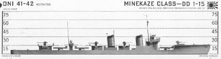
Description: Sighted a MINEKAZE class DD that was either anchored or underway and stopped, apparently standing by two beached ships, another DD and a small AK. Fired three torpedoes all of which hit. |
|
|
|
Ship(s) Sunk: MINEKAZE class Destroyer (EC) |
|
Ship(s) Damaged or Probably Sunk: None |
|
Damage Determined By: Saw three hits; forward, aft, and amidships. Target had sunk to bridge level a minute later. When observed next, forty-five minutes later, he had disappeared. |
|
Target Draft: 9'5", Course: 143, Speed: 0, Range: 2670 Yds. (at firing) |
|
OWN SHIP DATA |
|
Speed: 2.5 knots, Course: 271, Depth 60 ft., Angle: 0° (at firing) |
|
FIRE CONTROL AND TORPEDO DATA |
|
Type Attack: Fired tubes 1, 2, and 3 on a 53 port track at range of 2700 yards at destroyer dead in the water. Torpedoes aimed at bow, MOT and stern by periscope. Torpedoes set to run at five feet in calm sea with no wind. Three hits. Torpedoes smoked prohibitively all the way down the range. |
|
|
|
| Tubes Fired |
#1 |
#2 |
#3 |
| Track angle |
53 P |
53 P |
53 P |
| Gyro Angle |
3°30' L |
3°40' L |
4"10' L |
| Depth Set |
5' |
5' |
5' |
| Power |
High |
High |
High |
| Hit or Miss |
Hit |
Hit |
Hit |
| Erratic |
Normal |
Normal |
Normal |
| Mark Torpedo |
23 |
23 |
23 |
| Serial Number |
53035 |
52780 |
26854 |
| Mark Exploder |
6-4 |
6-4 |
6-4 |
| Serial Number |
8378 |
21827 |
17405 |
| Actuation Set |
Contact |
Contact |
Contact |
| Actuation Actual |
Contact |
Contact |
Contact |
| Mark Warhead |
16-1 |
16-1 |
16-1 |
| Serial No. |
12810 |
13167 |
12758 |
| Explosive |
Torpex |
Torpex |
Torpex |
| Firing Interval |
0 |
8 sec. |
8 sec. |
| Type Spread |
Aimed by Periscope |
| Sea Conditions |
One |
One |
One |
|
|
|
|
| |
|
|
| U.S.S. BATFISH |
Torpedo Attack No. 2 |
Patrol No. 4 |
|
|
Time: 1300, Date: 25 August |
Lat. 7-10°25'N, Long: 134°31'E |
|
Target Data - Damage Inflicted |
|
Description: Sighted a large PC type patrol vessel at a range of 3500 yards on a southerly course, speed 12 knots heading for YOO channel. Fired 4
Mark 18 Torpedoes, all of which missed. |
|
|
|
Ship(s) Sunk: None |
|
Ship(s) Damaged or Probably Sunk: None |
|
Damage determined by: Torpedoes missed |
|
Target Draft: 5',
Course: 180 for #7,8,9; 030 for #10, Speed: 12 knots for #7,8,9; 4.5 knots for #10
Range: 1200-1300 for 7,8,9; 1900 Yds. for #10 |
|
OWN SHIP DATA |
|
Speed: 2.5, knots Course: 100, Depth: 65 ft., Angle: 0° (at firing) |
|
Type Attack: Periscope approach. Fired tubes #7, 8 , and 9 (Mark 18 torpedoes). Torpedoes set to run at 3 feet on a 140 port track, range 1250 yards using a 3° spread. All missed. I believe these torpedoes broached and ran erratic, although I can't prove it except in explaining the targets action. The torpedoes had 40° left gyro angles and I was watching the target and not the direction in which the torpedoes were running. Sound tracked the torpedoes but the actual course on which they were running on was lost in the shuffle. Sea
conditions were number 3, visibility about 8000 yards. Shortly after firing target turned sharply to left and then stopped. Obtained another set up on new course and fired tube number ten on a 68 starboard track, range 1900 yards, torpedo set to run at four feet. Just as soon as the torpedo was fired, the target's screws started up and he swung toward us. This torpedo was tracked as running hot straight and normal and missed astern. |
|
|
|
| Tubes Fired |
#7 |
#8 |
#9 |
#10 |
| Track angle |
140 P |
141 P |
142 P |
068 S |
| Gyro Angle |
136 |
137-30 |
144-30 |
150-30 |
| Depth Set |
3' |
3' |
3' |
3' |
| Power |
--- |
--- |
--- |
--- |
| Hit or Miss |
Miss |
Miss |
Miss |
Miss |
| Erratic |
Unknown |
Unknown |
Unknown |
Unknown |
| Mark Torpedo |
18 |
18 |
18 |
18 |
| Serial Number |
53724 |
53643 |
53754 |
53882 |
| Mark Exploder |
4-7 |
4-7 |
4-7 |
4-7 |
| Serial Number |
16289W |
16751W |
16271W |
16233W |
| Actuation Set |
Contact |
Contact |
Contact |
Contact |
| Actuation Actual |
--- |
--- |
--- |
--- |
| Mark Warhead |
18 |
18 |
18 |
18 |
| Serial No. |
W11 |
W1128 |
W847 |
W304 |
| Explosive |
Torpex |
Torpex |
Torpex |
Torpex |
| Firing Interval |
0 |
10 sec. |
10 sec. |
4 min. 0 sec. |
| Type Spread |
0 |
3° Left |
3° Right |
0 |
| Sea Conditions |
Moderate |
Moderate |
Moderate |
Moderate |
| Overhaul Activity |
None |
None |
None |
None |
|
|
|
|
| |
|
|
| U.S.S. BATFISH |
Torpedo Attack No. 3 |
Patrol No. 4 |
|
|
Time: 1830, Date: 26 August |
Lat. 8-8°30'N, Long: 134°37'E |
|
Target Data - Damage Inflicted |
|
Description: The target, a destroyer aground on NGARUANGL REEF, was destroyed by two hits from Mark 18-0 torpedoes. |
|
|
|
Ship(s) Sunk: one FUBUKI class destroyer (EC) |
|
Ship(s) Damaged or Probably Sunk: None |
|
Damage determined by: Observed two hits which broke target in half just aft of #2 stack. five days later watched the Japanese blow up what remained of the wreckage. |
|
Target Draft: 9'9", Course: 105, Speed: 0 knots, Range: 2970 Yds (at firing) |
|
OWN SHIP DATA |
|
Speed: 2.5, knots Course: 207, Depth: 60 ft., Angle: 0° (at firing) |
|
FIRE CONTROL AND TORPEDO DATA |
|
Type Attack: Periscope attack at dusk on a beached destroyer. Fired Mark 18 torpedoes from tubes 7 and 8 set to run at three feet and four feet respectively, range 2970 yards, gyro angles 182 and 183. Sea calm but with long low ground swells, visibility fair, sky completely overcast. First torpedo partially broached three times but hit the target just aft of the #2 stack on a 101 starboard track. Second torpedo broached once, but ran straight and hit the target in practically the same place, breaking the ship in half. Stern sunk of slid off the reef but the bow
remained fast. Later observed the Japs blow up what remained of the wreckage. |
|
|
|
| Tubes Fired |
#7 |
#8 |
| Track angle |
101 S |
104 S |
| Gyro Angle |
182 |
183 |
| Depth Set |
3' |
4' |
| Power |
--- |
--- |
| Hit or Miss |
Hit |
Hit |
| Erratic |
No |
No |
| Mark Torpedo |
18 |
18 |
| Serial Number |
53951 |
53896 |
| Mark Exploder |
4-7 |
4-7 |
| Serial Number |
16244W |
16355W |
| Actuation Set |
Contact |
Contact |
| Actuation Actual |
Contact |
Contact |
| Mark Warhead |
18 |
18 |
| Serial No. |
144W |
740W |
| Explosive |
Torpex |
Torpex |
| Firing Interval |
0 |
3 min. 0 sec. |
| Type Spread |
0° |
0° |
| Sea Conditions |
Moderate |
Moderate |
| Overhaul Activity |
PROTEUS |
PROTEUS |
|
|
|
|
(I) Mines |
|
One floating mine was sunk by 20 MM fire in Latitude 25°-43'N., Longitude 171°-44'E. This mine was encrusted with barnacle and did not explode.
Two minelayers were observed in the vicinity of VELASCO REEF but appeared to be patrolling rather than planting mines. |
|
(Ia) Torpedoes |
|
Electric Torpedoes: Eight Mark XVIII torpedoes were carried in the after torpedo room.
The routines outlined in "Maintenance Instructions for Mark XVIII Torpedoes" was rigorously adhered to and as a result no difficulties were encountered in handling this torpedo.
Each torpedo was ventilated 24 hours after receipt on board and at 48 hour intervals thereafter.
The torpedoes were charged at regular intervals of 6 to 7 days depending upon the specific gravity. Torpedoes were ventilated immediately after charging, 24 hours later, and at 48 hour intervals thereafter.
Just prior to entering the patrol area the torpedoes in the racks were exchanged
with those in the tubes to minimize the possibility of unnecessarily dewatering the cells while on patrol.
On August 25th, fired four Mark XVIII torpedoes at a Patrol Craft in a number 2-3 sea. Three
were fired with a depth setting of three feet, and one with a depth setting of four feet. All broached and the target ship successfully avoided.
On August 27th fired two Mark XVIII torpedoes at a FUBUKI class destroyer grounded on a reef. Three foot and four foot depth settings were used and torpedoes partially broached, but ran hot straight and normal. Two hits were observed.
Steam Torpedoes: Twelve Mark XIV-3A and for Mark XXIII torpedoes with Mark VI-4 exploder mechanisms installed were carried in the forward torpedo room.
The following defects are noted:
1. Torpedo serial number 52780 Mark XXIII charging check valve leaked allowing the loss of 60 pounds air pressure per day. Torpedo was charged each day until expended.
2. Torpedo serial number 39689 Mark XIV-3A. Combination charging check valve and midship section leaks (source undetermined) resulted in the loss of an average of 130 pounds pressure per day. Torpedo was charged daily.
3. Torpedo serial number 40792 Mark XIV-3A. As a result of the rapid loss of pressure, the
after buoy was removed and the starting valve lead checked and found loose. Reassembled the recharged air flask but torpedo continued to lose approximately 400 pounds pressure a day. Apparently there is a small hole in the starting valve nipple. Torpedo was charged to 2800 pounds and the charging valve secured. No loss of pressure was noted after the charging valve was secured. |
|
(J) Anti-Submarine Measures and Evasive Tactics |
|
Anti-submarine patrols were conspicuous by their absence, the only ones
encountered being those in and around VELASCO REEF. It was particularly amusing to find none active off the several passage through the reef. The surface and air screens around the beached ships at NGARUANGL REEF were ineffective and inefficient, although the surface patrols were undoubtedly
handicapped by the loud reef noises and the air patrols by the sudden squalls that come up at odd intervals.
Evasive tactics consisted of taking advantage of these reef noises and periods of low visibility, and, after the attack on the PC, of going deep and running at 4 knots for a short period of time. |
|
(K) Major Defects and Damage |
|
No. 2 Kleinschmidt Distilling
Unit after producing battery water for 22 days, overnight, commenced making salty water. The coils were disassembled, cleaned and tested; three leaky tubes were silver soldered, and the unit re-assembled. It continued to make
salty water, although potable. The unit had 176 hours of use since last cleaning, and 1698 total hours of operation.
The Q3 sound head was not used throughout the patrol because misalignment of shafting caused noisy training and leaky packing. This sound head had been damaged on BATFISH's Third Patrol and was repaired by U.S.S. PROTEUS repair force at Midway, where no spare shaft was available. |
|
(L) Radio |
|
Communications in general were vary satisfactory. Only one "Haiku" number was missed because of weak signals and noises. Approximately 18% of Haiku numbers sent were missed during the run due to being
transmitted while we were submerged and not being repeated at night. Three messages were transmitted. No difficulty being experienced on the first two but considerable interference, mainly by USN ships
and stations, resulted in being unable to obtain receipt for third message. Message was received by Subron Ten and forwarded by him to Comsubpac. It was a message of considerable length and its transmission was interrupted and held up for some time by the transmission of an "O" by another ship. When the "Go ahead" signal was received signals were beginning to fade and
interference increasing which resulted in losing contact with NPM 8480 Kcs was used. No attempt being made on any other frequency.
16.68 Kcs was received S5 until about 500 miles west of Midway at which time we shifted to the higher frequencies. No attempt was made to copy this frequency afterwards.
4525 Kcs was S5 but some interference made it less desirable than 6380 and 9090 during the night hours. 6380 was very good throughout entire patrol with very good signals and only slight interference. 9090 was
also very satisfactory with the exception of 2 or 3 nights of rather heavy interference and "Jamming." Signals on 9090 were S5 from about 0500-1700 zebra each day.
14390 and 17370 were both S5 during daylight hours. A period of about two hours from 1800 to 2000 zebra proved rather difficult during most of the patrol. 9090 would fade about that time and although 14390 came on at 1900 it was not very good until about 2000
Two short message were transmitted on 4475 Kcs (Voice) to 13th AAF Liberators
during one of their raids, 28 August, on PALAU. No answer was received
from them and it is unknown whether they received our message or not. Communications between the
Liberators was intercepted on the APR on 140 Mcs during each of their raids. Nothing was received from them on 4475 Kcs at any time.
Shifted to radio control VIXO at 0900 zebra three September, using frequencies 12630, 9250, and 4370. Traffic was received strength 5 on 12630 and 9250 between 21 and 18 hours zebra. Fading of signals occurs between 18 and 21 hours zebra. Unable to hear on 4370. |
|
(M) Radar |
|
SJ RADAR: The SJ Radar was operated from dusk until dawn throughout the patrol without mishap. The new type basket antenna was installed just prior to leaving on patrol, but we were unable to adequately judge its performance insomuch as ship contacts were conspicuous by their absence.
On several occasions, considerable and rapid maneuvering of the BATFISH resulted from sizeable pips appearing at from 2000 to 3000 yards range and moving at speeds up to 15 knots. These phantoms turned out to be over-friendly birds.
Ranges on land were considered satisfactory - Palau being obtainable at 60,000 yards.
Rain squalls could be picked up on the radar out to 20,000 yards.
Faint radar interference was picked up on the SJ at 2000 on August 8, 1944 bearing 240 degrees T. and again at 2100 on August 16, 1944 bearing 250 degrees T. No response was obtained to the challenge sent by keying our transmitter.
SD RADAR: The SD radar was not manned during most of the time on station to prevent the enemy from D.F.'ing us, being turned on only during scheduled daylight strikes and once or twice while in vicinity of VELASCO REEF. During the period of its operation, ranges were obtained out to 50 miles on AAF Liberators,
with the average ranges on unidentified planes being between 15 and 20 miles.
Enroute to the area, a plane closed to within 2 miles before being detected by the SD and another to 4 miles (cloudy day). This poor performance was found to be due to a faulty adapter plug provided at Midway for plugging the RF coaxial cable into the receiver. The performance of the RF amplifier provided in the last refit
was doubtful and it was not used after the first few days.
APR-1 RADAR DETECTOR: The Radar Detector was manned continuously during the time we were surfaced and
considerable enemy radar was fond to be on the air around Palau. During the
bombing of Palau by AAF planes, voice was heard loud and clear on several occasions at 138 MC.
Enemy radar signals in the area were:
153 Mgc. Most frequently encountered usually strongest, and with a variable speed sweep. Loudest signal received when we were in vicinity of PELELIU and KORROR.
157 Mgc. Strong signal, sometimes sweeping and very often steady. This installation must be situated on the northern end of BABELTHUAP.
175 Mgc. Strong sweeping signal near ANGUAR Island.
The following additional frequencies were encountered only once, and all, while BATFISH was close
to land: 80, 269, 121, 147, 65, 99, 105, 252, 265. |
|
(N) Sound |
|
Sound conditions in the area agreed with previous reports; in general being excellent when away from the reef noises close to land.
The JP-1 and the QC-JK sound gears functioned without mishap. However, the QB gear which was damaged on the last run, became a victim of misalignment troubles early in the patrol and had to be kept secured because of excessive vibration and high noise level in train.
Enemy echo ranging was on 17 Kcs. |
|
(O) Density Layers |
|
| No. |
Date |
ZT (-9) |
Lat. |
Long. |
Remarks |
|
1 |
12 August |
0645 |
9°15'N |
135°45'E |
Isothermal to 260'. |
|
2 |
14 August |
0645 |
6°57'N |
135°47'E |
Isothermal to 180'. 2° net. grad. to 270' |
|
3 |
16 August |
0600 |
7°50'N |
134°21'E |
Isothermal to 220'. 1° neg. grad. to 250' |
|
4 |
25 August |
1400 |
7°12'N |
134°32'E |
Isothermal to 160'. 3° neg. grad. to 350' |
|
5 |
26 August |
1700 |
8°8'N |
134°37'E |
Isothermal to 160'. 1° neg. grad. to 240' |
|
|
(P) Health, Food, and Habitability |
|
Food in general was excellent and varied. Fresh fruit, apples and oranges, were still being served forty days after leaving Midway and were a welcome addition to the diet.
The ventilation of the forward battery and forward torpedo room was augmented during the last refit by the addition of a booster blower and an air conditioning unit in the hull vent line in the control room. While this
arrangement served its original purpose very nicely it was found to have a few draw backs, robbing Peter to pay Paul. The blower, a 500 cfm impellor type, partially cut down the ventilation in the crews mess, magazine, and radio shack, and took all the air intended for the conning tower and pump room. In addition it is prohibitively noisy, and it is believed that both situations could be improved if this blower were replaced by a smaller one of about 200 cfm.
Health was excellent after the first week away from Midway. Two cases of catarrhal fever were being treated when we left, and this spread to ten inside of three days but all responded to normal treatment and the minor epidemic was cleared up after the first week. One man is suffering from a chronic ulcer on left leg which is healing slowly. Treatment consisted of sulfanilamide powder, sterile dressing with sterile vaseline
gauze drain. |
|
(Q) Personnel |
|
| What a crew! |
|
|
|
| Men transferred after last patrol |
24 |
| Men making this patrol |
74 |
| Men qualified at start of patrol |
43 |
| Men qualified at end of patrol |
53 |
| Unqualified men making first patrol |
18 |
| Men advanced in rating |
14 |
|
|
(R) Miles Steamed - Fuel Used |
|
| Midway to area |
3442 Miles |
35490 Gals. |
| In Area |
2848 Miles |
24620 Gals. |
| From Area to Fremantle |
3192 Miles |
34850 Gals. |
|
|
(S) Duration |
|
| Days enroute to area |
11 |
| Days in area |
21 |
| Days enroute to base (Fremantle) |
9 |
| Days submerged |
7 |
|
|
(T) Factors of Endurance Remaining |
|
| Torpedoes |
15 |
| Fuel |
20,110 Gals. |
| Provisions |
20 Days |
| Personnel Factor |
9 Days |
|
|
(U) Remarks |
|
The impression I took away with me from this once very active area, is that the enemy never recovered from the carrier raid of last spring and that his present strategy does not include PALAU as a major base for his ships and planes. The absence of patrols and fighter opposition to the Liberator strikes seemed significant in itself and the half hearted attempt to re-enforce the, shall I say, beleaguered
garrison, was nipped in the bud by the timely attack by the HARDHEAD on the early morning of August 18. I predict that, when and if an attempt is made to take these islands, the opposition will be surprisingly light. |
|
|
Torpedoes fired: 9 |
|
Number of hits: 5 |
|
Ships sunk: 2 |
|
Ships sunk (Official): 2 |
|
Tonnage: 2,900 |
|
Tonnage (Official): 2,072 |
|
This patrol was designated as successful for the Combat Insignia Award |
|
|
|
Sunk: Minekaze Class DD - 1200 tons (Officially credited as
Minesweeper W 22 - 492 tons) |
|
Details: Torpedo Attack #1 on 8/23/44 |
 |
|
|
 |
|
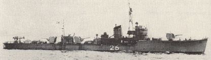
Minesweeper No. 22 belonged to the No. 7 class (648 tons), similar to No. 26
pictured above. |
|
|
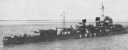
Sunk: Samidare ( Destroyer) - 1,580
tons
(Officially credited) |
|
Details: Torpedo Attack #3 on 8/26/44 |
 |
|
|
Pictures courtesy of Shelley Shelstad and History-on-cdrom.com |
|
|
|
