| (A)
Prologue |
|
BATFISH arrived Pearl from fifth war patrol on December 1, 1944. Refit and administration assigned to Submarine Squadron FOUR, Submarine
Division 282, Submarine Division 42, and Submarine Base. During the refit period the following major alterations were completed:
Installation of 5" gun and 40mm gun.
Installation of Gould Trim Pump
Installation of hand type signal gun.
Installation of safety plates for deck hatches.
Installation of Mark 8 T.B.T. and Mark 3 D.R.T.
Installation of radar bearing transmitter and repeaters for true and relative bearings.
Post repair and training period commenced December 18, 1944. Sound tested December 20. Five day training
period during which time fired three exercise torpedoes. Commander P.S. Benson, U.S. Navy, the training officer, was
exceptionally helpful and cooperative. Included in the training period were two days of special exercises. Ready for sea December 30, 1944.
During the refit a total of 67 alterations were undertaken and while the majority of these were completed during the 16 day refit period, some were carried over into the training period and while they didn't of themselves prevent the proper execution of the training, they more or less constituted a "thorn in the side" to the ship's company and I believed that when a boat that has been away from a home base for any length of time, and therefore is way behind on necessary alterations (such as we were), her refit period should be extended from two to four days to
allow for the proper installation of these items.
On December 18, Lieutenant C.K. Sprinkle relieved Lieutenant Commander J.M. Hingson as executive officer. Lieutenant (jg) H.J. Morin, U.S. Navy was detached and relieved by Ensign R.H. Pepper, U.S. Navy on December 3, 1944. |
|
(B) Narrative |
| 30 December |
| 1330(VW) |
Underway from Submarine Base Pearl Harbor, T.H. in accordance with ComSubPac operational order. Proceeding in company with U.S.S. CHARR under escort PC 465 |
| 1743(W) |
Escort departed. Went ahead flank (4 engine speed). |
| 1950(W) |
Trim dive. |
| 31 December |
|
Enroute GUAM, at four engine speed. Making training dives and conducting drills and
exercises enroute. |
| 0945(W) |
Exchanged recognition signals with U.S. Submarine. |
| 1-9 January, 1945 |
|
Enroute GUAM at four engine speed. Conducting training dives and drills
enroute. |
| 4 January |
| 1030(M) |
Exchanged recognition signals and calls with a U.S. Submarine. |
| 7 January |
| 1842(K) |
SJ radar interference. Exchanged recognition signals with U.S.S. BLACKFISH. |
| 8 January |
| 0005(K) |
Joined U.S.S. BLACKFISH. Proceeding in company to prescribed rendezvous. |
| 9 January |
| 0220(K) |
Rendezvous with PC 1126. Proceeding GUAM under escort. |
| 0903(K) |
Moored alongside U.S.S. ARCHERFISH to U.S.S. SPERRY, APRA HARBOR, GUAM. |
| 10 January |
| 1702(K) |
Underway in accordance with ComSubPac operation order, under escort, in company with U.S.S. ARCHERFISH and U.S.S. BLACKFISH as unit of Task Group 17.16, known as Joe's Jugheads. Commander Task Group, Commander J.E. Enright, Commanding Officer U.S.S. ARCHERFISH. Conducting tracking and communication drills enroute to patrol area in South China Sea. |
| 2230(I) |
Escort departed. |
| 11 January |
| 0830(I) |
Sighted what appeared to be a floating mine but turned out to be a mooring buoy. Held target practice with all small caliber guns. |
| 1440(I) |
SD contact 18 miles with IFF response, closed to 11 and then opened. Not sighted from bridge. |
| 12 January |
| 1101(I) |
PBM at 10 miles, closed to 4 and exchanged recognition signals. |
| 1605(I) |
ARCHERFISH sighted periscope. Took evasive action. |
| 13 January |
| 1000(I) |
Received report of downed aviators near our track. |
| 1600(I) |
SD contact 15 miles closed to 6 with no IFF so at |
| 1603(I) |
Dove. |
| 1632(I) |
Surfaced. |
| 14 January |
| 0228(I) |
SD contact 26 miles. Closing, no IFF. |
| 0834(I) |
Plane at 6 miles - dive. |
| 0903(I) |
Surfaced. |
| 0930(I) |
SD contact 22 miles, opened to 29 and disappeared. IFF response, not sighted from bridge. These planes are undoubtedly searching for the downed aviators. |
| 1000(I) |
Request to conduct independent search to northward was not granted by group commander. |
| 1317(I) |
Sighted life raft. Went alongside to investigate. Raft was empty as was a nearby life jacket. This was a ship type raft and was painted white with no identifiying marks. |
| 1647(I) |
Sighted empty watertight type box which may have been used by the survivors for whom we are searching. |
| 2047(I) |
Dove |
| 2100(I) |
Surfaced. |
| 15 January |
|
All times hereafter are now (-8) unless otherwise indicated. |
| 2355 |
Radar contact on CAMIGUIN and BABUYAN Islands. Commenced passage of BALINGTAME CHANNEL. Wind and sea picking up and shifting to N.N.E. |
| 16 January |
|
Proceding through Luzon Straits. |
| 0851 |
SD contact 16 milies closing - no IFF. |
| 0853 |
Plane at 10 miles - dove. Since the weather had deteriorated, decided to stay down a while and routine torpedoes. |
| 1040 |
Surfaced. |
| 1130 |
Plane at 16 miles closing fast. |
| 1132 |
Dove. |
| 1219 |
Surfaced. |
| 1418 |
Plane contact 14 miles, moved out to 15 and disappeared. |
| 1436 |
Plane contact 9 miles; closed to 6 so at |
| 1440 |
Dove. |
| 1517 |
Surfaced. |
| 1518 |
Plane at 18 miles closing. |
| 1519 |
Dove. |
| 1706 |
SD contact 20 miles, closed
to 6 so at |
| 1746 |
Dove. |
| 1837 |
Surfaced. Strong APR signals at 152 mgcs. |
| 2053 |
SJ contact on FORMOSA at 80,000 yards. The unusually large number of plane contacts today may have been the result of the recent strikes by blue ships and planes in this area, or may even have been friendly patrols. In no case was there any IFF response and in no case could any radar signals be detected. The sky has been completely overcast all day and rough seas made an
efficient lookout impossible, so we manned the SD and perhaps the Japs were homing on it. |
| 17 January |
|
Patrolling to westward south of Hong Kong. |
| 0601 |
Dove. Fire in the after distribution board. Had to remain submerged all day to effect repairs (see Defects and Damage). Was without lights, ventilation and several other conveniences all of which made for a very uncomfortable day. |
| 1804 |
Surfaced. |
| 18 January |
|
Patrolling to westward off TONKON POINT, HAINAN. Weather stormy with heavy seas. |
| 0631 |
Dove. |
| 1323 |
Surfaced. |
| 1658 |
Sighted floating mine (horn type). Attempts to destroy it by gunfire were of no avail due to rough seas and low visibility and after an hour of target practice lost contact. (Lat. 20-39 N; Long. 113-10 E). |
| 19 January |
|
Patrolling to eastward off TAYA ISLANDS. |
| 0642 |
Dove. |
| 1330 |
Surfaced. |
| 1405 |
Received word of downed aviators so headed for their probably track, although it is doubtful whether a man could survive long in this weather. |
| 1845 |
Sighted floating mine which passes down the starboard side at about 75 yards. Unable to regain contact. (Lat. 19-58 N.; Long. 112-03 E). |
| 20 January |
| 0643 |
Dove. |
| 0953 |
Surfaced, continued search for downed aviators. |
| 2012 |
Headed west so as to be in position for a submerged patrol off east coast of HAINAN tomorrow. Weather has improved considerably. |
| 21 January |
| 0043 |
Dove for submerged patrol along east coast of HAINAN in vicinity of TONKON POINT. |
| 1851 |
Surfaced. |
| 22 January |
|
Patrolling north and south along east coast of HAINAN. |
| 0645 |
Dove. |
| 1855 |
Surfaced. |
| 2120 |
Received China plane contact regarding ships in TONKIN GULF west of HAINAN. Plot shows one convoy to be headed east through HAINAN STRAIT and we should be able to contact them tonight, or if they anchor at night, we can intercept them tomorrow. |
| 23 January |
| 0115 |
SJ contact 090 at 24,000 yards. Identified as a plane. No radar signals on APR. Disappeared at 14 miles. |
| 0209 |
SJ contact at 9,800 yards. Two pips. Targets tracked on course 180, speed varying between three knots and one knot. It looked suspicious so eased in to 3,500 yards, where we could see two large shapes from bridge, but could hear no screws or echo ranging. Since the pips were rather small, decided they could be one of a dozen things and not wishing to give ourselves away to the expected convoy, decided to track them
until daylight and make a submerged approach if they were bonafide targets. |
| 0535 |
Radar contact 17,000 yards. We were now 8,000 yards ahead of our original contact and the new contacts tracked on course 350 but at only two knots. This new contact is ahead and we are on the track of each group and in good position for an attack on either. |
| 0610 |
Contact developed into many ships, at least twelve. |
| 0613 |
Could see dim outline of both groups of ships so at |
| 0615 |
Dove and went to battle stations submerged. |
| 0639 |
All ships were identified as Chinese Junk type sailing vessels. Counted a total of 28 of them, so decided to Battle Surface and determine if they were by any chance carrying valuable Japanese cargos. |
| 0711 |
Surfaced and started in. |
| 0730 |
Commenced firing with all guns from 2,000 yards range. After hitting one ship several times
all the vessels hove to. Maneuvered the ship alongside four, taken at random, and determined them to be
harmless Chinese fishermen, most boats having whole families, men, women, children, and even babies aboard. Went alongside and sent off boarding party to inspect for contraband, but a thorough search revealed nothing but a few days catch of fish of various and unappetizing types. Gave them a little bread, beans and rice for the scare we had given them, and then headed for the one we had hit and damaged to board her. After many bows, lots of sign language, found out they weren't so concerned about their damaged boat (several holes in the hull, one mast shot down, rigging partially demolished), or that two men had been shot, but
that they wanted help fixing up the wounds. Send the pharmacist mate over to take his practical factor for C.P.O. He had two good patients and I'll never forget the demonstration I had of plain
intestinal fortitude. One, and old man, had a wound in his thigh and didn't even flicker an eyelash while it was being treated. The other had two wounds, one in his back and one in his arm, but he was
the most active person aboard. we stocked their larder with cigarettes, beans, and rice and parted the best of friends. |
| 0950 |
Left the junk fleet and headed east. |
| 1000 |
Sighted plane (EMILY) at about 7 miles. Dove. |
| 1630 |
Surfaced. Many junks still in sight. |
| 1745 |
Sighted floating mine which we exploded with 20mm fire. (Lat. 20-10 N., Long. 111-54 E.) |
| 24 January |
|
Patrolling to northward of HAINAN STRAITS. |
| 0413 |
SJ contact 12,907 yards. Commenced tracking. Contact proved to be another junk fleet. |
| 0634 |
Dove. |
| 0807 |
Surfaced. |
| 1122 |
Sighted floating mine (horn type). Destroyed with 20mm fire. (Lat. 20-15 N; Long. 111-24 E.) |
| 25 January |
| 0553 |
SJ contact 7,000 yards. Manned radar tracking stations and
since we were not sure these were junks, at |
| 0633 |
Dove on their track. |
| 0651 |
Identified targets as more junks. Decided to remain submerged and patrol off TAYA ISLANDS today. |
| 1758 |
Surfaced. |
| 1930 |
Received word of possible downed aviator. Headed for most probably spot. |
| 26 January |
| 0250 |
SJ radar interference. |
| 0555 |
Exchanged calls with ARCHERFISH on SJ radar. |
| 0629 |
Surfaced. Searching for downed plane. |
| 1412 |
Sighted floating mine (horn type). Destroyed by 20mm fire. (Lat. 19-54 N; Long. 112-10 E). |
| 27 January |
|
Several contacts during night which turned out to be more Chinese Junks. |
| 0640 |
Dove for submerged patrol off TONKON POINT. |
| 1846 |
Surfaced. |
| 28 January |
| 0642 |
Dove. |
| 1833 |
Surfaced. |
| 2107 |
SJ contact 11,000 yards, three pips. Tracked on southerly course at 1 1/2 knots. Closed
to visual range and identified three more junks. |
| 29 January |
| 0635 |
Dove for patrol off TAYA ISLANDS. |
| 1833 |
Surfaced. Received plane report of ships anchored in YULIN BAY. Although this is a little out of our area, headed south and told SoWesPac boats in adjoining areas we were moving into their baliwick. |
| 2008 |
Sighted two lights on horizon. Commenced tracking. |
| 2031 |
Identified contacts as junks. |
| 30 January |
| 0500 |
Land radar signals on 199 mgcs. |
| 0623 |
Dove south of YULILN BAY. |
| 0900 |
Reconnoitered YULIN anchorage from 6,000 yards. No shipping. |
| 1300 |
Observed GAALONG BAY - no shipping. |
| 1358 |
Sighted unidentified plane at about 9 miles. |
| 1600 |
One bomb. Not close and I doubt if we were the target. More likely this was a token bomb dropped by a China Recco plane. |
| 1816 |
Sighted BETTY at about 4 miles. |
| 1911 |
Surfaced. |
| 2000 |
Radar signals 199 mgcs. Strong. |
| 2016 |
Plane contact at 5 miles, bearing 075 T. Also sighted from bridge. |
| 2017 |
Dove. |
| 31 January |
| 0644 |
Dove off YULIN BAY. |
| 0903 |
Sighted small tug coming out of YULIN. Turned to investigate. |
| 0952 |
Sighted another small tug or pilot boat and it looks like there might be something coming in today. |
| 1001 |
Sighted small freighter on a
westerly course, 8000 yards. Went to battle stations. |
| 1026 |
Fired tubes 1, 2, and 3 on a 990 port track, 1000 yards range, torpedoes set for four feet, using 3� spread. Sound tracked all torpedoes to, under, and away from target. I don't know when I have ever been so disappointed. I was so sure of getting this one we even had the cameras ready to start taking
pictures and if there was ever a storybook set up, this was it. |
| 1030 |
Target turned northward to enter YULIN, but decided to follow him anyway in hopes of getting another shot. |
| 1038 |
Sighted plane at about 2 miles, zooming over our AK. |
| 1225 |
Have been following target since we fired and she is now anchored in the inner harbor at YULIN. No chance for another shot at present, but we'll hang around until she comes out. |
| 1904 |
Surfaced. |
| 1 February |
|
Patrolling east and west in TONKIN GULF. |
| 0624 |
Dove off YULINKAN. SJ plane contact 10,000 yards, closing fast. Radar signal, strong and steady at 198 mgcs. |
| 1030 |
Sighted smoke bearing 070� T. Battle stations submerged. |
| 1122 |
Lost race with small AK when he entered harbor ahead of us. Identified as same ship as yesterday. Once again, he came out of GAALONG BAY and entered YULIN, but how and when he moved out of YULIN since this time yesterday I don't know. At any rate, we were out of position to intercept and never got closer than 4,200 yards. During this approach we passed a red nun
buoy close aboard to starboard, the significance of which is unknown, but it may be the seaward marker for the turn into YULIN. The AK passed inside it about 2,000 yards but apparently used it to turn on. |
| 1235 |
Ship got underway and headed east toward SAMA. Went to 90 feet and headed so as to intercept, running at standard speed. |
| 1258 |
A look revealed ship had turned east and was headed for GAALONG. Tracked at 8 knots, and once again we are out of position. This is beginning to get irksome, especially running around in shoal and poorly charted waters at 6 knots submerged, but we have now definitely established his route and the next time he makes this milk run we know where to be so that he can't possibly get by. |
| 1457 |
Sighted SALLY on a westerly course at about 8 miles. |
| 1700 |
Heard echo ranging (distant) but was unable to determine the source. |
| 1906 |
Surfaced. |
| 1935 |
Searchlight, in vicinity of SAMA, which went on and off several times. |
| 2 February |
|
Patrolling east and west of TONKIN GULF south of HAINAN. |
| 0002 |
Received orders changing our patrol area. Hate to leave here now that we have "cased the
joint" so well and feel that nothing could get by us again. Headed for LUZON STRAITS at three engine speed. |
| 1140 |
Sighted unidentified aircraft coming out of clouds with zero angle on bow. Loud APR signal at 158 mgcs. Contact four miles on SD. Dove. |
| 1411 |
Surfaced. Weather deteriorating. |
| 3 February |
|
Proceeding toward LUZON STRAITS in heavy weather. |
| 1900 |
Received orders to join with PLAICE, SCABBARDFISH, ARCHERFISH, and BLACKFISH for patrol in LUZON STRAITS. |
| 4 February |
| 0615 |
Surfaced. |
| 1000 |
Dove. |
| 1714 |
Sighted medium sized LBV on a northerly course, range about 4,000 yards. It was much too
rough to man deck guns but determined to see what we could do with 40 and 20mm. Target had a light
machine gun mounted in bow but no other armament was visible. |
| 1743 |
Commenced firing with 40 and 20mm and 50 caliber machine gun from ranges varying from 1,000 to 50 yards. The sea
was so rough that any speed over 120 turns swamped the bridge on most courses and since the target kept a zero or 180� angle on the bow as much as possible found we were unable to use our
superior speed to any advantage. In addition it started to rain and that coupled with approaching night made for poor visibility. Target returned fire for a short time after we had moved in to 100 yards and sprayed him with 20mm and 50 caliber from point blank range, either his gun was gone, his personnel killed or he had lost his fight because we received no
return fire. At one time, when we were about 50 yards from target he attempted
to ram. However before we could polish him off, it got pitch black and at |
| 1835 |
Ceased firing as target was no longer visible at close range even, and all 40 and 20mm ammunition, except that in deck stowage, which we were unable to get to was gone. This was a very much shot up ship, and even if he hadn't sunk at the time, I doubt very much if he can make the 100 or so miles to FORMOSA in this sea, and it's questionable
whether anyone was left alive, or if alive was not mortally wounded. |
| 1900 |
Received orders from PLAICE to patrol pass between BABUYAN and CALAYAN ISLAND. |
| 2225 |
SJ plane contact, 24,000 yards, closed and then opened as it crossed ahead. |
| 5 February |
|
Patrolling in LUZON STRAITS, high wind, heavy sea, poor visibility. |
| 0840 |
SJ plane contact, 18,000 yards, closed to 6 miles so at |
| 0842 |
Dove. |
| 0850 |
Surfaced. |
| 6 February |
|
Submerged patrol in pass between BABUYAN and CALAYAN ISLANDS. |
| 7 February |
| 0018 |
SJ plane contact 12,000 yards. Disappeared at 14,000. No radar signals on APR. Submerged patrol in pass between BABUYAN and CALAYAN ISLANDS. |
| 1118 |
Sighted plane (SALLY) at about 4 miles. |
| 2000 |
Requested and received permission to patrol in BABUYAN Channel south of CAMIGUIN ISLAND. |
| 2125 |
Loud radar signals, 176 mgcs. |
| 8 February |
| 0526 |
SJ plane contact on SJ at 14,000 yards. Lost at 10 miles. |
| 0555 |
Dove. Patrolling southeast and northwest in BABUYAN CHANNEL south of FUGA ISLAND. |
| 1819 |
Surfaced. |
| 2114 |
SJ plane contact, 21,600 yards. Lost contact at 15 miles. |
| 2141 |
Plane contact 10,600 yards. Verified on SD and lost at 12 miles. |
| 9 February |
|
Patrolling in BABUYAN CHANNEL south of CAMIGUIN Island. |
| 0555 |
Dove. |
| 1758 |
Sighted plane at about 8 miles heading southeast.
Believed to be a BETTY. |
| 1823 |
Surfaced. |
| 2210 |
Radar signal on APR at 158 mgcs, 500 PRF. |
| 2250 |
SJ contact bearing 240 True, 11,000 yards. Commenced tracking. Target tracked on course 310�, speed 12 knots so went to battle stations and commenced approach, broadcasting dope to other wolves in pack. Saturation signals on
APR at 158 mgcs which increased in intensity as range decreased. |
| 2331 |
Commenced firing tubes 1, 2, 3, and 4 on 130� starboard track gyros practically zero, range 1850 yards torpedoes set for six feet using a 2� divergent spread. All missed. |
| 2339 |
(10s-40s) Four end of run explosions. Pulled out to 5,000 yards off target's track and commenced new end around while making reload. The night was very dark, no moon, partially overcast and target was not
seen on first run but was believed to be a Japanese submarine. Decided to close to visual range for next attack and verify type of contact but tentatively set torpedo depths at 4 feet, 2 feet, 2 feet, and 0 feet. |
| 10 February |
| 0001 |
With range to target 1020 yards a Japanese I class submarine was clearly visible from bridge. We were in a beautiful position - 90 track zero gyros so at |
| 0002 |
Commenced firing tubes forward. #1 was a hot run in the tube, #2 hit, and number three passed over spot where submarine sank. The hit was accompanied by a brilliant red explosion that lit up the whole sky and the target sank almost immediately Radar
indications on the APR ceased abruptly. This radar signal was apparently non-directional type, and probably anti-aircraft since we closed to 900 yards without his giving any indication that he was aware of our presence. Target disappeared from visual sight and on radar screen almost immediately, screws stopped and loud breaking up noises
were heard on sound gear. |
| 0010 |
Heard one end of run explosion. |
| 0015 |
Commenced reload forward, sent results of attack to pack commander and rigged searchlight preparatory to returning to scene and search for survivors. |
| 0120 |
Very strong oil smell, heavy slick on water. A cut shows we are two miles east of the point of attack. Turned on searchlight and after
a short experiment decided we were advertising ourselves needlessly and accomplishing little except ruining the night vision of the bridge personnel and probably drawing airplanes. |
| 0150 |
After running through the "spot" several times decided to wait until daylight and come back to investigate. It was too dark to have been able to see any debris or survivors and while oil slick was indication that submarine had sunk, would still like to salvage some Nip submariners and see what makes them tick. |
| 0510 |
Plane contact on SJ 9,000 yards. Verified on SD. |
| 0512 |
Three planes seven miles. These lads are going to make our daylight search a little difficult. |
| 0540 |
SJ plane contact 12,000 yards. Verified on SD. |
| 0541 |
Another plane at 5 miles. |
| 0543 |
One plane coming in fast on port quarter, range 7,000 yards. Since dawn is breaking and it is fairly light in spite of being overcast, decided it was time to hide, so dove. Plane was at 3
miles when SD went under. APR had saturation signal at 179 mgcs. |
| 0947 |
Sighted five planes bearing 180� True, distance about 4 miles, heading west. One, identified as a Black Cat was flying low, separately investigating the same oil slick we were; ie. the remains of our last nights target. The other four were fighters acting as escorts. Unfortunately BATFISH failed to go to deep submergence. |
| 1008 |
While taking another look, sound heard a torpedo running on port beam. nothing in sight except four of the planes which are close aboard on port bow. (One fighter was not seen on this sweep). Went deep. Torpedo passed overhead and went away on bearing 150� relative. A tender moment and if these actually prove to be blue
planes a very unfriendly act. My theory on the attack is that the patrol plane launched the torpedo and the one fighter we could not see was spotting us overhead flying down our track. |
| 1812 |
Surfaced. |
| 1930 |
PLAICE, SCABBARDFISH, and SEAPOACHER, received orders to patrol elsewhere. PACK consisting o fARCHERFISH, BLACKFISH and BATFISH to revert to former designation of Joe's Jugheads and continue patrol in LUZON STRAITS. |
| 2000 |
Radar signals on APR at 178 mgcs. |
| 2038 |
SJ radar plane contact, bearing 280� True, 15,000 yards, crossing astern. |
| 2042 |
Another plane on port bow. Then commenced the now familiar tactics employed by the Jap's anti-submarine planes and when range had closed to 9,000 yards, with plane coming in on a steady baring at 330�, and with APR at saturation 178 mgcs, at |
| 2044 |
Dove to 200 feet. |
| 2128 |
Surfaced. Weak APR signal but no contacts. |
| 2150 |
SJ plane contact 15,000 yards on port bow. Crossed ahead and out to 18,000 yards; then turned and came in on a steady
bearing of 030�. With range 10,000 yards at |
| 2157 |
Dove to 200 feet. |
| 2254 |
Surfaced. All clear. I guess
the planes have found somebody else to annoy. |
| 11 February |
| 0100 |
Received orders from pack commander to
patrol west of CALAYAN. Cannot make it tonight so will stay where we are until tomorrow. |
| 0510 |
SJ plane contact 14,000 yards, crossing ahead from port to starboard, closed to 9,000 yards and disappeared at 24,000 yards. No APR signals. |
| 0548 |
Dove. |
| 1820 |
Surfaced. |
| 1837 |
Two plane contacts on SJ at 21,500 yards. Indications of 178 mgcs radar. Plane disappeared at 12 miles. |
| 1915 |
Radar signals on APR at 158 mgcs, 500 PRF. Since this is the same radar as we found on our submarine target last night, started searching very carefully on SJ and swung ship
in order to find null in the signal, thereby determining the approximate true bearing of the source. |
| 1951 |
Radar contact on SJ at 8,000 yards, bearing 310� True. Manned battle stations and commenced tracking. Since, if
anything, it is darker than last night; and since we had found how ineffective the Jap radar was, decided to make a surface attack if possible and close target sufficiently to identify him by class. |
| 2037 |
Sighted target from bridge at range 1,300 yards, identified as submarine with no shears, very low in water, and perhaps slightly smaller than our last target. |
| 2043 |
With range to target 1,200 yards, on a course for a 90� starboard track, had made up my mind to shoot when the gyro angles decreased 10 more degrees to 10� left when at |
| 2043-30 |
Signal on APR went off and target dove. Changed course to left and speeded up, in the meantime trying to reconcile myself to the fact that I had lost this one by trying to wait for the theoretically perfect set up. Why he dove became a point of discussion because at |
| 2105 |
Just one half hour later sound heard a swishing noise from general direction of target that was universally accepted as the sound of a submarine blowing his ballast tanks. At |
| 2106 |
Sure enough, APR showed that 158 mgcs was back on and SJ made contact 8,650
yards, bearing 018� True. Whether the target head us or thought he heard us; saw us or thought he saw us; had us on his radar or thought he did or just make a normal and routine night dive I don't know; but I do know that unless he has radar detector that will intercept our SJ, he's going to have a hard time finding us this time. |
| 2109 |
Manned battle stations and started end around. |
| 2150 |
With range to target 6,000 yards, dove to radar depth. Target had speeded up, from 7 knots to 12 knots, and now tracked on base course 120� True. |
| 2202 |
Commenced firing four tubes forward on a 100� starboard track, 880 yards range, torpedoes set to run at four feet using a 1 knot speed spread. |
| 2202-50 |
First hit, timed as first torpedo. Target literally blew apart
and sank almost immediately. |
| 2203-07 |
Another muffled hit. Probably the third torpedo doing likewise. |
| 2207 |
Two loud explosions, believed to be internal explosions. Maybe this guy was carrying ammunition to General YAMASHITA. |
| 2210-02 |
One end of run explosion. |
| 2211 |
One more explosion, very loud, which shook up the boat considerably. Thought at first it was a close bomb, but then realized it was the finale to the swan song of one Nip submarine. During this time and for the next 15 minutes sound had a variety of noises
identified as small internal explosions, escaping air, etc. |
| 2230 |
Taking sweep prior to surfacing, had possible plane
contact at 5 miles. Dropped down to 100 feet. |
| 2341 |
Surfaced. Set course for assigned area to west of CALAYAN Island. Reported results of attack to pack commander. |
| 12 February |
| 0536 |
SJ plane contact bearing 340� T., 12,300 yards closing. |
| 0538 |
Dove for submerged patrol west of CALAYAN Island. |
| 1823 |
Surfaced. Headed southeast for pass between CALAYAN and DALIPARI Islands. |
| 2000 |
Received orders from pack commander to search for downed aviator west of SABTANG and BATAN Islands. |
| 13 February |
| 0155 |
Weak APR signal at 157 mgcs, 500 PRF. In hopes that this may be another Nip sub, started swinging ship to get approximate bearing of source. |
| 0215 |
SJ radar contact 220� True, range 10,700 yards. Commenced tracking. |
| 0227 |
Target tracks on base course 120 at 7 knots. Looks like another Nip sub so manned battle stations submerged and commenced approach. |
| 0241 |
With range to target 7150 yards,
he dove, why I'll never know, but he probably had a plane contact, or thought he did. Headed to a position ahead of him on his track so as to be in position when and if he surfaces. |
| 0310 |
APR signal at 157 back on again so submarine must be surfaced
or taking a sweep. |
| 0353 |
Finally regained contact
after a few bad moments when we thought he was making an approach on us. Target now
bears 336� True, range 9,800 yards. Commenced new approach. |
| 0412 |
Dove on targets track at 6,800 yard range and went to radar depth. |
| 0430 |
Swung for 90 track with stern tubes. Tide rips are making depth control and steering very difficult and I hope they don't adversely effect the torpedo. |
| 0448 |
Commenced firing 3 tubes aft on an 80 starboard track, zero gyros 1500 yard torpedo run, using a 1 knot speed spread. Torpedoes set for 6 feet. |
| 0449-30 |
Saw first torpedo hit and target sank immediately. Target could be seen blowing apart on radar screen
and the explosion was accompanied by a large yellow ball of fire and seen through periscope. The second and third torpedoes missed, not due to
errors in data, but because target sank so quickly. |
| 0452 |
Surfaced and headed for oil slick. |
| 0457-08 |
Explosion - end of run. |
| 0457-43 |
Second end of run explosion. |
| 0500 |
Ran through oil and wreckage
debris. Attempted to use the searchlight to search area and again this proved to be futile and unproductive method, due mainly to the wide diffusion of the beam and the short effective range so decided to stay surfaced until after daylight, planes permitting. |
| 0620 |
After sighting several bits of wood and paper, lots of oil, but no survivors; our search for something tangible was rewarded when we recovered a wooden box that was found to contain Japanese navigation equipment and a book of tables. From the positions listed in the work book, it looks like this guy went from NAGOYA to FORMOSA before he headed down to LUZON to join his ancestors. |
| 0630 |
Dove. |
| 1835 |
Surfaced. Headed toward area west of CALAYAN Island to search for aviator reported in water. |
| 14 February |
| 0121 |
Sighed white flare bearing 345� True. Headed toward it and fired green very star. |
| 0430 |
After thoroughly searching locality, and firing green very stars every 15 or 20 minutes with no answer, decided perhaps flare had been a shooting star. Although the lookouts and officer of the deck stick by their guns. Shortly thereafter received word
that aviator had been recovered by own planes. |
| 0542 |
Dove. |
| 1827 |
Surfaced. |
| 15 February |
|
Patrolling pass between CALAYAN and FUGA and FUGA and CAMIGUIN Islands. |
| 0550 |
Dove. |
| 1840 |
Surfaced. |
| 16 February |
|
Patrolling as before. |
| 0539 |
SJ plane contact, 18,000 yards closing. |
| 0540 |
Dove. |
| 1820 |
Surfaced. Departed station and headed for prearranged rendezvous with U.S.S. BLACKFISH. |
| 17 February |
| 0725 |
Rendezvous with U.S.S. BLACKFISH. Proceeding in company to GUAM. |
| 1220 |
Plane contact at 18 miles on SD, opening. |
| 18 February |
| 1045(I) |
Exchanged calls and numbers with a U.S. Submarine. |
| 1050(I) |
Sighted plane on horizon.
No contact on SD. |
| 20 February |
| 0758(I) |
Plane contact on SD at 10 miles. Sighted from bridge and appeared to be a B-32. Exchanged visual calls. |
| 21 February |
| 0340(I) |
Rendezvous with escort, PC 1072. |
| 0920(K) |
Moored port side to U.S.S. APOLLO (AS25), APRA Harbor, GUAM. Voyage repairs by APOLLO and Submarine Squadron 28. |
| 22 February |
| 1815(K) |
Underway for Pearl Harbor under escort, PC 1082. |
| 23 February |
| 0815(K) |
Escort departed. Proceeding Pearl at 16 knots. |
| 3 March |
| 0710(IK) |
Rendezvous with escort, PC 1078 and U.S.S. ARCHERFISH. |
| 1400(IK) |
Moored at Submarine Base, Pearl Harbor, T.H. |
|
(C) Weather |
|
Typical weather for the time of year and area was experienced. Extremely rough weather was encountered west of 121� East. Depth control was difficult while operating off east coast of HAINAN. A decided change was noted south of HAINAN and good periscope weather was experienced. A definite dividing line in the LUZON Straits at 20� North was noted. South of this latitude the weather was moderate while to the north rough weather was again experienced. The sky was overcast 75 percent of the time. |
|
(D) Tidal Information |
|
Currents followed generally as shown on H.O. Misc. No. 10,047-A-1 and larger scale H.O. Charts. Tide rips were encountered between islands in the LUZON Straits. |
|
(E) Navigational Aids |
|
No navigational aids were observed. A red
nun buoy was seen 5,000 yards south of the entrance to YULINKAN Bay. Shipping passed inboard of this buoy when entering. |
|
(F) Ship Contacts |
|
| No. |
Time Date |
Lat. Long |
Type(s) |
Initial Range |
Est. Course
and Speed |
How Contacted |
Remarks |
|
------------------------------------------------------------------------------------------------------------------------------------------------------ |
| 1 |
2015 (H)Jan. 23 |
20�17' N 111� 36' E |
Chinese Junks |
9,800 yds. |
2 Kts. 150� T |
SJ |
Sighted at 0337. Battle Surfaced at 0730 Jan. 23.
See Gun Attack #1. |
| |
Every day while operating off
East Coast of HAINAN encountered from two to thirty of these Junks. |
|
------------------------------------------------------------------------------------------------------------------------------------------------------ |
| 2 |
2015
(H) Jan. 29 |
19�10' N 111�08' E |
Chinese Junks or small fishing boats |
8,400
yds |
4 Kts.
050� T |
SJ |
|
|
------------------------------------------------------------------------------------------------------------------------------------------------------ |
| 3 |
1440
(H) Jan. 30 |
18�07' N 109�39' E |
Sailing Vessel |
4,000
yds. |
3 Kts.
270� T |
Periscope |
|
|
------------------------------------------------------------------------------------------------------------------------------------------------------ |
| 4 |
0903
(H) Jan. 31 |
18�05' N 109�37' E |
Tug |
7,000
yds. |
6 Kts.
120� T |
Periscope |
Apparently waiting for small AK |
|
------------------------------------------------------------------------------------------------------------------------------------------------------ |
| 5 |
0952
(H) Jan. 31 |
18�06' N 109�38' E |
Pilot
Boat |
7,000
yds. |
4 Kts.
120� T |
Periscope |
|
|
------------------------------------------------------------------------------------------------------------------------------------------------------ |
| 6 |
1001
(H) Jan. 31 |
18�06' N 109�36' E |
Small
AK |
8,000
yds. |
8 Kts.
260� T |
Periscope |
See
Torpedo Attack #1 |
|
------------------------------------------------------------------------------------------------------------------------------------------------------ |
| 7 |
1030
(H) Feb. 1 |
18�05' N 109�33' E |
Small
AK |
12,000 yds |
8 Kts.
270� T |
Periscope |
|
|
------------------------------------------------------------------------------------------------------------------------------------------------------ |
| 8 |
1714
(H) Feb. 4 |
21�00' N 119�50' E |
LBV |
4,000
yds. |
12
Kts. 000� T |
Bridge |
See
Gun Attack #2 |
|
------------------------------------------------------------------------------------------------------------------------------------------------------ |
| 9 |
2250
(H) Feb. 9 |
18�50' N 121�40' E |
Japanese "Item" Class Submarine |
11,000 yds. |
13
Kts. 310� T |
SJ |
See
Torpedo Attack #2 & #3 |
|
------------------------------------------------------------------------------------------------------------------------------------------------------ |
| 10 |
1951
(H) Feb. 11 |
18�53' N 121�50' E |
Japanese "Item" Class Submarine |
8,000
yds. |
12
Kts. 120� T |
APR -
SJ |
See
Torpedo Attack #4 |
|
------------------------------------------------------------------------------------------------------------------------------------------------------ |
| 11 |
0215
(H) Feb. 13 |
19�10' N 121� 23' E |
Japanese "Item" Class Submarine |
10,700 yds. |
6 Kts.
140� T |
APR -
SJ |
See
Torpedo Attack #5 |
|
------------------------------------------------------------------------------------------------------------------------------------------------------ |
|
|
(G) Aircraft Contacts |
|
| No. |
Time |
Date |
Latitude |
Longitude |
Type |
Ranges |
Bearing & Course |
How Contacted |
| 1 |
1600 (I) |
13 January |
15�30'N |
130�10'E |
|
15 - 6 mi. |
|
SD
(Dove) |
| 2 |
0828 (I) |
14 January |
15�11'N |
126�21'E |
|
26 - 6 |
|
SD
(Dove) |
| 3 |
0851 (H) |
16 January |
20�19'N |
121�10'E |
|
16 - 10 |
|
SD
(Dove) |
| 4 |
1130 (H) |
16 January |
20�32'N |
121�00'E |
|
16 - 11 |
|
SD
(Dove) |
| 5 |
1418 (H) |
16 January |
20�52'N |
120�45'E |
|
14 - 18 |
|
SD |
| 6 |
1436 (H) |
16 January |
20�54'N |
120�43'E |
|
9 - 6 |
|
SD
(Dove) |
| 7 |
1517 (H) |
16 January |
20�56'N |
120�42'E |
|
18 |
|
SD
(Dove) |
| 8 |
1742 (H |
16 January |
21�05'N |
120�33'E |
|
20 - 6 |
|
SD
(Dove) |
| 9 |
0138 (H) |
23 January |
20�10'N |
111�40'E |
|
14 |
|
SD -
SJ |
| 10 |
1000 (H) |
23 January |
20�08'N |
111�45'E |
EMILY |
7 |
Bt-100� T, Ct-240� T |
Sighted from Bridge (Dove) |
| 11 |
1358 (H) |
30 January |
18�07'N |
109�38'E |
BETTY |
8 |
Bt-345� T, Ct-090� T |
Periscope |
| 12 |
1816 (H) |
30 January |
17�58'N |
109�27'E |
BETTY |
4 |
Bt-180� T, Ct-000� T |
Periscope |
| 13 |
2015 (H) |
30 January |
17�47'N |
109�32'E |
|
5 |
Bt-075� T |
(Dove) |
| 14 |
1038 (H) |
31 January |
18�08'N |
109�36'E |
JACK |
2 |
Bt-090� T, Ct-180� T |
Periscope |
| 15 |
0624 (H) |
1 February |
17�58'N |
109�34'E |
|
5 |
Bt-290� T |
Periscope |
| 16 |
1457 (H) |
1 February |
18�07'N |
109�33'E |
SALLY |
8 |
Bt-050� T, Ct-270� T |
Sighted from Bridge (Dove) |
| 17 |
1535 (H) |
1 February |
18�07'N |
109�35'E |
|
10 |
Bt-315� T, Ct-230� T |
SD -
SJ |
| 18 |
1140 (H) |
2 February |
19�22'N |
112�41'E |
EMILY |
4 |
Bt-020� T, Ct-180� T |
SJ |
| 19 |
2225 (H) |
4 February |
20�38'N |
120�18'E |
|
12 |
Bt-250� T |
SD -
SJ |
| 20 |
0840 (H) |
5 February |
20�35'N |
121�22'E |
|
9 |
Bt-160� T |
SJ |
| 21 |
0018 (H) |
7 February |
19�12'N |
121�43'E |
|
6 - 5 |
Bt-180� T |
SD -
SJ |
| 22 |
1118 (H) |
7 February |
19�15'N |
121�46'E |
SALLY |
4 |
Bt-123� T, Ct-315� T |
Periscope |
| 23 |
0526 (H) |
8 February |
18�53'N |
121�39'E |
|
7 |
Bt-080� T |
SD -
SJ (Dove) |
| 24 |
2114 (H) |
8 February |
18�36'N |
121�50'E |
|
11 |
Bt-252� T |
SJ |
| 25 |
2140 (H) |
8 February |
18�35'N |
121�51'E |
|
5 |
Bt-102� T |
SD -
SJ |
| 26 |
1758 (H) |
9 February |
18�47'N |
121�40'E |
Betty |
8 |
Bt-248� T, Ct-140� T |
Periscope |
| 27 |
2328 (H) |
9 February |
18�56'N |
121�47'E |
|
9 |
|
SD |
| 28 |
0510 (H) |
10 February |
18�56'N |
121�33'E |
Two
Planes |
5 |
Bt-147� T |
SD -
SJ |
| 29 |
0540 (H) |
10 February |
18�59'N |
121�30'E |
|
6 |
Bt-190� T |
SD -
SJ |
| 30 |
0947 (H) |
10 February |
18�59'N |
121�33'E |
1 PBY,
4 F6F |
4 |
Bt-180� T, Ct-270� T |
Periscope |
| 31 |
2038 (H) |
10 February |
18�44'N |
121�43'E |
|
8 |
Bt-280� T |
SJ
(Dove) |
| 32 |
2150 (H) |
10 February |
18�48'N |
121�41'E |
|
7 |
Bt-305� T |
SJ
(Dove) |
| 33 |
0510 (H) |
11 February |
18�46'N |
121�41'E |
|
7 -15 |
Bt-250� T |
SJ |
| 34 |
1837 (H) |
11 February |
18�49'N |
121�40'E |
Two
Planes |
11 |
Bt-250� T |
SJ |
| 35 |
0536 (H) |
12 February |
19�17'N |
121�12'E |
|
6 |
Bt-340� T |
SD -
SJ |
| 36 |
0539 (H) |
16 February |
19�20'N |
121�15'E |
|
9 |
Bt-240� T |
SJ
(Dove) |
| 37 |
2130 (H) |
16 February |
19�51'N |
121�20'E |
|
12 |
Bt-045� T |
SD -
SJ |
|
|
(H) Attack Data |
|
U.S.S. Batfish |
Torpedo Attack No. 1 |
Patrol No. 6 |
|
Time: 1026(H), Date: 31 January, 1945 |
Lat. 16�07'N., Long. 109�37'E. |
|
Target Data - Damage Inflicted |
|
Description: Sighted a small MFM AK proceeding along south coast HAINAN between GAALONG and YULINKAN Bays, close in to the beach. A medium sized tug and a smaller vessel, probably a pilot boat, were standing off entrance to YULIN. |
|
|
|
Ship(s) Sunk: None |
|
Ship(s) Damaged or probably Sunk: None |
|
Damage Determined by: Torpedos underran target. |
|
Target Draft: 4 feet, Course: 250�T., Speed: 9 knots, Range: 1110 yds (at firing) |
|
OWN SHIP DATA |
|
Speed: 2.5 knots, Course 350� T., Depth: 64 feet, Angle: 0� (at firing) |
|
FIRE CONTROL AND TORPEDO DATA |
|
Type Attack: Periscope attack
against a small AK which was proceeding along south coast of HAINAN between GAALOG and YULINKAN Bays. Target was against land background and was not sighted until range was 8,000 yards. Made a normal periscope approach. Took a single ping range just prior to firing which agreed
with generated range an with a perfect set up and all data generating beautifully, fired three Mark 18-2 from bow tubes on an 98 port track, 1,000 yard torpedo run, using a 3� divergent spread. Torpedoes set to run at four feet. Sound tracked all torpedoes
to, under and away from target. At the start of the approach ordered a two
foot depth setting, but when target was better identified unfortunately assumed his draft to be greater and the state 3 sea unsuitable for firing torpedoes with shallow settings. A hard one to lose, especially with a storybook set up like this. |
|
|
|
| Tubes Fired |
#1 |
#2 |
#3 |
| Track Angle |
96 P |
98 P |
104 P |
| Gyro Angle |
350-30 |
351-50 |
50-20 |
| Depth Set |
4' |
4' |
4' |
| Power |
--- |
--- |
--- |
| Hit or Miss |
Miss |
Miss |
Miss |
| Erratic |
No |
No |
No |
| Mark Torpedo |
18-2 |
18-2 |
18-2 |
| Serial No. |
57602 |
57545 |
57686 |
| Mark Exploder |
4-7 |
4-7 |
4-7 |
| Serial No. |
17021 |
97101 |
17407 |
| Actuation Set |
Impact |
Impact |
Impact |
| Actuation Actual |
--- |
--- |
--- |
| Mark Warhead |
18-0 |
18-0 |
18-0 |
| Serial No. |
1095 |
9314 |
488 |
| Explosive |
Torpex |
Torpex |
Torpex |
| Firing Interval |
12 sec. |
12 sec. |
12 sec. |
| Type Spread |
3� L |
0� |
3� R |
| Sea Conditions |
Choppy |
Choppy |
Choppy |
| Overhaul Activity |
Navy #128 |
|
|
|
|
| U.S.S. Batfish |
Torpedo Attack #2 |
Patrol No. 6 |
|
|
Time: 2330(H), Date: 9 February, 1945 |
Lat. 18�50'N, Long. 121�33'E |
|
Target Data - Damage Inflicted |
|
Description: Target, later identified as a Japanese I class submarine, was contacted by SJ radar at initial ranges of 11,000 yards. Target was proceeding toward pass between FUGA and CANIGUIN Islands at
speed of 12 knots on a direct course from Cape BATULINAO. Steady radar signals at 158 mgcs, 500 PRF. |
|
|
|
Ship(s) Sunk: None |
|
Ship(s) Damages or probably Sunk: None |
|
Damage determined by: All torpedoes missed and were heard to explode at end of run. |
|
Target Draft: 16 feet, Course: 309� T., Speed 12 knots, Range: 1850 yds. (at firing) |
|
OWN SHIP DATA |
|
Speed: 5 knots, Course 269� T, Depth: 0 feet, Angle: Surface (at firing) |
|
FIRE CONTROL AND TORPEDO DATA |
|
Type Attack: Night radar attack on surface. First indications of a target was a steady 158 mgcs, 500 PRF radar signal that rapidly became louder and reached saturation shortly after contact was made. Initial contact 11,000 yards. Target tracked on course 310� True at a speed of 12 knots. The night was dark, no moon, sky overcast, so decided to make attack on surface if possible. Since horizon was darkest to eastward made the attack from that direction and at 2330 fired four Mark 18-2 torpedoes from bow tubes, range 1850 yards, torpedoes set to run at six feet. Average track angle 145� starboard, gyros 10� right using 2� divergent spread. All torpedoes missed probably astern (speed later solved at 14 knots) and were heard to explode at the end of run eight minutes later. Target at no time showed any indications that she was aware of our presence nor did she become
alerted by the end of run explosions. she may have assumed these latter to be a bombing attack on northern LUZON. Pulled off track and started new approach. |
|
|
|
| Tubes Fired |
#1 |
#2 |
#3 |
#4 |
| Track Angle |
145 S |
145 S |
145 S |
150 S |
| Gyro Angle |
010.5 |
010 |
009-40 |
011-10 |
| Depth Set |
6' |
6' |
6' |
6' |
| Power |
--- |
--- |
--- |
--- |
| Hit or Miss |
Miss |
Miss |
Miss |
Miss |
| Erratic |
No |
No |
No |
No |
| Mark Torpedo |
18-2 |
18-2 |
18-2 |
18-2 |
| Serial No. |
57582 |
57574 |
57622 |
57341 |
| Mark Exploder |
4-7 |
4-7 |
4-7 |
4-7 |
| Serial No. |
17113 |
17011 |
17267 |
17272 |
| Actuation Set |
Contact |
Contact |
Contact |
Contact |
| Actuation Actual |
All exploded at end of run |
| Mark Warhead |
18-0 |
18-0 |
18-0 |
18-0 |
| Serial No. |
957 |
9295 |
9317 |
567 |
| Explosive |
Torpex |
Torpex |
Torpex |
Torpex |
| Firing Interval |
12 sec. |
12 sec. |
12 sec. |
12 sec. |
| Type Spread |
4� R |
2� R |
0� |
2� L |
| Sea Conditions |
1 |
1 |
1 |
1 |
| Overhaul Activity |
Navy #128 |
| Remarks: Torpedoes probably missed astern due to error in target's speed. |
|
|
|
|
| U.S.S. Batfish |
Torpedo Attack #3 |
Patrol No. 6 |
|
|
Time: 0002(H), Date: 10 February, 1945 |
Lat. 18�56'N, Long. 121�34'E |
|
Target Data - Damage Inflicted |
|
Description: Same target as attack number two. Identified visually as an I class Japanese submarine. |
|
|
|
Ship(s) Sunk: One I class Japanese Submarine (EC). |
|
Ship(s) Damaged or probably Sunk: None. |
|
Damage determined by: Saw one torpedo hit from a range of 900 yards. Target exploded with a brilliant red flame and sank almost immediately leaving a large oil slick that extended
over a radius of two miles. Target could be seen blowing apart on radar screen. |
|
Target Draft: 16 Feet, Course 020� T., Speed: 14 knots, Range: 990 yards (at firing) |
|
OWN SHIP DATA |
|
Speed: 5 knots, Course: 290� T., Depth: 0 Feet, Angle: Surfaced (at firing) |
|
FIRE CONTROL AND TORPEDO DATA |
|
Type Attack: Night surface radar attack. After
opening out from target's track following first attack on this target, commenced new end around. Target tracked at 14 knots and shortly after we had started the approach she changed base course to 020� T. in order to clear FUGA Island. Decided to stay on surface, since, judging from the first attack on this target, his radar is either not very efficient or else it is anti-aircraft only. Also, again utilized the
favorable dark background to eastward. With range to target 1500 yards he was visible from bridge and when ranged closed to 1020 yards identifiable as an I class Japanese submarine. At the beginning of the approach had set torpedoes at depths of 4 feet, 2 feet, 2 feet and zero feet. When target was positively identified he was on the firing bearing for a 90� starboard track, and gyros had already started to increase so commenced firing immediately. First torpedo was a hot run in the tube. It fired on second try but was already running in tube and I believe it ran
erratic. The second torpedo, fired on an 115� starboard track with a 30� right gyro and range 920 yards hit and the target sank almost immediately. The third torpedo missed and exploded at the end
of its run eight minutes later. Secondary explosions, believed to be internal explosions in the target were heard three minutes later after the ship was hit. |
|
|
|
| Tubes Fired |
#1 |
#2 |
#3 |
| Track Angle |
107 S |
115 S |
125 S |
| Gyro Angle |
019-10 |
033-10 |
038-30 |
| Depth Set |
4' |
2' |
2' |
| Power |
--- |
--- |
--- |
| Hit or Miss |
Miss |
Hit |
Miss |
| Erratic |
Yes |
No |
No |
| Mark Torpedo |
18-2 |
18-2 |
18-2 |
| Serial No. |
57508 |
57661 |
57542 |
| Mark Exploder |
4-7 |
4-7 |
4-7 |
| Serial No. |
17424 |
47286 |
17201 |
| Actuation Set |
Contact |
Contact |
Contact |
| Actuation Actual |
--- |
Contact |
End of Run |
| Mark Warhead |
18-0 |
18-0 |
18-0 |
| Serial No. |
462 |
950 |
914 |
| Explosive |
Torpex |
Torpex |
Torpex |
| Firing Interval |
0 sec. |
18 sec. |
12 sec. |
| Type Spread |
4� R |
0� |
4� L |
| Sea Conditions |
1 |
1 |
1 |
| Overhaul Activity |
Navy #128 |
| Remarks: Number one tube was fired and ran hot in the tube. It was fired with impulse pressure (150#) but did not eject, however, it did start running. On a second try it did eject, but probably ran erratic. |
|
|
|
|
| U.S.S. Batfish |
Torpedo Attack #4 |
Patrol No. 6 |
|
|
Time: 2202(H), Date: 11 February, 1945 |
Lat. 18�53'N, Long. 121�47'E |
|
Target Data - Damage Inflicted |
|
Description: Thirty six minutes after receiving initial radar signal on APR at 158 mgcs, 500 PFR made SJ contact with Japanese submarine, range 8,000 yards, on southeasterly course heading for vicinity of BATULLINAO BAY at 7 knots. Before establishing contact swung ship to find null in APR signal to get
approximate bearing of target. |
|
|
|
Ship(s) Sunk: One Japanese submarine (EC). Submarine class not definite but believed to be "Item." |
|
Ship(s) Damaged or probably Sunk: None. |
|
Damage determined by: Target was hit three times with Mark 18-2 torpedoes and literally blew apart. Internal explosions and characteristic sinking noises on sound gear continued from half and hour after target sunk. |
|
Target Draft: 16 Feet, Course: 120� T., Speed: 12 knots, Range: 880 yds. (at firing) |
|
OWN SHIP DATA |
|
Speed: 3 knots, Course: 021� T., Depth 44 Feet, Angle: 0� (at firing) |
|
FIRE CONTROL AND TORPEDO DATA |
|
Type Attack: Night radar attack. Presence of target was originally suspected when a radar signal at 158 mgcs was picked up on APR and rapidly getting louder. Initial contact was made at 8,000 yards. Target tracked on base course 135� True, constant helming 15� right and left and at a speed of 7 knots. In view of previous success in a night surface
attack against a similar target with similar radar, decided to make attack on surface in order to more fully identify her as she was believed to be a Japanese submarine. No moon, partially overcast, and rain squalls behind us, gave BATFISH the favorable lighting conditions. At range of 1800 yards target was sighted from bridge, and by the time it had decreased to 1200 it was identified as a Japanese submarine, similar to the "Item" class. About one minute before BATFISH was to commence firing, target dove. The reasons for this maneuver are unknown but by the process of elimination, I believe he either thought he saw us or thought he had our pip on his radar, or he was making a routine night dive. At any rate he surfaced twenty minutes later. The first indication that he had surfaced was a noise on sound gear coming from direction of target that was similar to that of a submarine blowing ballast tanks. Next his radar at 158 mgcs came in and finally a contact on the SJ at 8,650 yards. Started new approach and worked up ahead and then dove to radar depth. Target now tracked on base course 120� True at a speed of 12 knots. With a range of 880 yards, commenced firing four Mark 18-2 torpedoes from bow tubes on a 70� starboard track, 15� left gyros, using a 1 knot speed spread, torpedoes set to run at four feet. First torpedo hit after a timed run to target of 50 seconds and target sank almost immediately. Second and third torpedoes also hit but with a muffled explosion that indicated they had gone off by hitting a piece of the target or in the disturbance caused by the initial hit. Five minutes after firing, two loud explosions from direction of target and one more nine minutes after firing were interpreted as internal explosions marking the end of this particular ship. The fourth torpedo exploded at the end of an eight minute run. |
|
|
|
| Tubes Fired |
#1 |
#2 |
#3 |
#4 |
| Track Angle |
62 S |
64 S |
68 S |
76 S |
| Gyro Angle |
341 |
341-10 |
346-30 |
354-10 |
| Depth Set |
4' |
4' |
4' |
4' |
| Power |
--- |
--- |
--- |
--- |
| Hit or Miss |
Hit |
Hit |
Hit |
Miss |
| Erratic |
No |
No |
No |
No |
| Mark Torpedo |
18-2 |
18-2 |
18-2 |
18-2 |
| Serial No. |
57572 |
57668 |
57719 |
54666 |
| Mark Exploder |
4-7 |
4-7 |
4-7 |
4-7 |
| Serial No. |
17273 |
17028 |
17422 |
17273 |
| Actuation Set |
Contact |
Contact |
Contact |
Contact |
| Actuation Actual |
Contact |
Contact |
Contact |
End of Run |
| Mark Warhead |
18-0 |
18-0 |
18-0 |
18-0 |
| Serial No. |
1155 |
1081 |
481 |
1119 |
| Explosive |
Torpex |
Torpex |
Torpex |
Torpex |
| Firing Interval |
12 sec. |
12 sec. |
12 sec. |
12 sec. |
| Type Spread (Speed) |
0 |
-2 kts |
-1 kt |
+1 Kt |
| Sea Conditions |
1 |
1 |
1 |
1 |
| Overhaul Activity |
Navy #128 |
|
|
|
|
| U.S.S. Batfish |
Torpedo Attack #5 |
Patrol No. 6 |
|
|
Time: 0448(H), Date: 13 February, 1945 |
Lat. 19�10'N, Long. 121�25'E |
|
Target Data - Damage Inflicted |
|
Description: The target, a Japanese submarine of I class was proceeding on a
southeasterly course between CALAYAN and DALUPIRI Islands at six knots. |
|
|
|
Ship(s) Sunk: One Japanese Submarine (EC). I Class. |
|
Ship(s) Damaged or probably Sunk: None. |
|
Damage determined by: Saw one torpedo hit which
blew target apart and caused him to sink in less than 10 seconds. Searched
wreckage and recovered several books, papers, and equipment. Heavy oil slick which spread over large area.
Nearly two hours after attack oil was still bubbling to surface in spot where target sank. |
|
Target Draft: 16 feet, Course 140� T., Speed 6 knots, Range: 1700 yards (at firing) |
|
OWN SHIP DATA |
|
Speed: 3 knots, Course 220� T., Depth 44 feet, Angle 0� (at firing) |
|
FIRE CONTROL AND TORPEDO DATA |
|
Night attack and at radar depth. First indications of a target were weak APR signals on 157 mgcs, 500 PRF. Swung sub to determine approximate bearing. Initial contact was made at 10,700 yards. Commenced approach. Twenty six minutes
later with range to target 7150 yards on BATFISH's starboard side, target dove - reason unknown. Target had tracked on base course 120� True so headed for a spot ahead of and on it's track so as to be in position for an attack before dawn in
the event that he surfaces again. One hour and ten minutes after target dove contact was regained at a range of 9,600 yards. Started new approach. With range to target 6,800 yards dove
on his track and continued approach from radar depth. Since we have only two torpedoes forward swung for a stern shot and fired three Mark 18-2 torpedoes from stern tubes on a 80� starboard track, zero gyros. Torpedo run
was 1,500 yards. Used a 1 knot speed spread and set torpedo depth at six feet. All torpedoes ran hot, straight, and normal, but after the first hit there was no target for the other two and they both exploded at end of run. One ran
for 8 minutes and 53 seconds, and the other for 9 minutes and 11 seconds. The hit was accompanied by a brilliant orange explosion and a wide diffusion of pips on the radar screen that indicated he literally blew apart. |
|
|
|
| Tubes Fired |
#7 |
#9 |
#10 |
| Track Angle |
76 S |
75 S |
80 S |
| Gyro Angle |
175-30 |
174-30 |
179-30 |
| Depth Set |
6' |
6' |
6' |
| Power |
--- |
--- |
--- |
| Hit or Miss |
Hit |
Miss |
Miss |
| Erratic |
No |
No |
No |
| Mark Torpedo |
18-2 |
18-2 |
18-2 |
| Serial No. |
57579 |
57513 |
57652 |
| Mark Exploder |
4-7 |
4-7 |
4-7 |
| Serial No. |
17347 |
17127 |
10762 |
| Actuation Set |
Contact |
Contact |
Contact |
| Actuation Actual |
Contact |
End of Run |
End of Run |
| Mark Warhead |
18-0 |
18-0 |
18-2 |
| Serial No. |
1269 |
661 |
4456 |
| Explosive |
Torpex |
Torpex |
Torpex |
| Firing Interval |
--- |
15 sec. |
17 sec. |
| Type Spread (Speed) |
0 |
-1 kt. |
+1 kt. |
| Sea Conditions |
1 |
1 |
1 |
| Overhaul Activity |
Navy #128 |
|
|
|
|
| U.S.S. Batfish |
Gun Attack #1 |
Patrol No. 6 |
|
|
Time: 0711(H), Date: 23 January, 1945 |
Lat. 20�10'N, Long. 111�44'E |
|
Target Data - Damage Inflicted |
|
Sunk: None. |
|
Damaged or probably Sunk: One Chinese Junk (100 tons). |
|
Damage determined by: Target was boarded and extent of damage observed. (3 holes in hull, after mast shot down, rigging partially demolished). |
|
Details of Action:
Initial contact was made at night by SJ radar. After observing targets (28 of them) from periscope depth during daylight, identified them as
Chinese Junks so surfaced with intention of stopping the group and searching for contraband. After firing a few rounds all vessels stopped and hove to. Went alongside four
taken at random and found them to be harmless Chinese fishermen. Gave them provisions as evidence of our good intentions and sent boarding party and pharmacist mate aboard one we had hit to give any aid possible.
Firing was opened at 3,000 yards and ceased at 2,000 yards. Following ammunition expended:
5"/25: 10 rounds HC
40 mm: 6 rounds HEI
6 rounds HET
2 rounds BLP
20 mm: 132 rounds HEI
75 rounds HET
6 rounds BLLP
.50 cal: 50 rounds |
|
|
|
| U.S.S. Batfish |
Gun Attack #2 |
Patrol No. 6 |
|
|
Time: 1745(H), Date: 4 February, 1945 |
Lat. 21�00'N, Long. 119�50'E |
|
Target Data - Damage Inflicted |
|
Sunk: None. |
|
Damaged or probably Sunk: While proceeding on surface in heavy weather and low visibility, sighted
small vessel dead ahead on a northwesterly course at about 4,500 yards range. After closing, was able to
identify it as a Japanese Landing Barge, very similar to the Allied LBV as shown in ONI 226. Its estimated length being in the neighborhood would indicated its tonnage as about 175 tons. |
|
Damage determined by: At least 50 40mm hits were seen and numerous 20mm and .50 caliber bursts sprayed the target from end to end. Target was strafed with one belt or about 130 rounds of .50 caliber from point blank range of fifty yards, and in spite of poor visibility numerous large holes could be observed. Target caught fire twice, but it did not take hold, probably due to heavy sea and the light rain. |
|
Details of Action
Because of heavy weather, was not able to use the 5" deck gun so closed the target to 1,200 yards and opened fire with 40mm. Target returned fire with a light machine gun so closed to about 500 yards and made several strafing runs with 20mm and .50 caliber. On one occasion target attempted to ram but at other times attempted t keep us on his stern. After hitting the target about 40 or 50 times with 40mm, during which time he
had caught fire twice, closed to about 50-75 yards and strafed him from point blank range. Since it had turned dark and target was not visible more than this range, broke off action. I believe all personnel had been killed or mortally wounded
and it is doubtful if this vessel could ever make port, sea conditions being
what they are and his condition being what it is. Nearest land is Formosa, 80 miles to the north.
Following ammunition was expended during this action:
20mm 288 rounds HEI
160 rounds HET
12 rounds BLP
40mm 72 rounds HEI
72 rounds HET
.50 caliber 500 rounds |
|
|
|
(I) Mines |
|
The only mines encountered were floating mines that had apparently broken loose from their moorings. A total of five were seen, all of which were of the horn contact type. Three of these were exploded with 20mm fire. Was unable to
destroy other two because of heavy weather and low visibility. Dates and positions of sightings are as follows:
1. January 18, 1945 - Lat. 20�29'N., Long. 113�10'E.
2. January 19, 1945 - Lat. 19�58'N., Long. 112�03'E.
3. January 23, 1945 - Lat. 20�10'N., Long. 111�54'E. Destroyed
4. January 24, 1945 - Lat. 20�15'N., Long. 111�24'E. Destroyed
5. January 26, 1945 - Lat. 19�54'N., Long. 112�16'E. Destroyed |
|
(J) Anti-Submarine Measures and Evasion Tactics |
|
Due undoubtedly to Third Fleet activities in this area during the second week in January, enemy surface patrols previously reported as active, particularly
in LUZON STRAITS and the Islands north of LUZON have either been sunk or withdrawn. However planes continue to fly anti-submarine patrols both day and night. The SD radar was used to take a sweep prior to surfacing in daylight and then kept turned off in the standby condition
and used only to check plane contacts, when ever the plane was lost on the PPI screen. Enemy planes encountered off
the China Coast and PAIMAN Island used radar that operated in the 150-170 mgcs band with a PRF of 1000. During the night of 10 February while patrolling pass between CAMIGUIN and FUGA Islands we were forced down twice by two very efficient search planes suing 178 mgcs radar. In both cases, contact was maintained on PPI making it easy to follow his maneuvers. Plane would cross our track, either ahead or astern at a range of 7 or 8 miles until he had cut us in and then would turn and come in either on the bow or quarter. When range had closed to 12,000 yards he started keying his radar.
Of the four contacts worthy of torpedoes, three were submarines and the fourth was a small coastal freighter which hugged the coast on his run from GAALONG BAY to YULINKAN Harbor. This ship was not escorted but a plane was observed to be flying around in tight circles in his general vicinity, and since we fired electric torpedoes I do not believe either was aware of our presence.
On February 10 a plane group identified as one Black Cat, escorted by four fighter planes, fired a torpedo at us which was evaded by going deep. |
|
(K) Major Defects and Damage |
|
The BATFISH has been in commission since August, 1943 and has completed six war patrols. During this
time she has suffered no major break downs and all equipment has been kept in an efficient and reliable operating condition, mainly through the efforts and attention to duty of the ship's force. The far reaching results of this type of care speak for themselves.
However the forthcoming Navy yard overhaul is coming at a time that will help in maintaining her ability to remain an efficient fighting unit while on station and prevent the break downs that come with age. Also it is hoped that all the hundred or so outstanding alterations will be accomplished, and thus bring her up to date with the newest and
best improvements.
A brief summary of the defects and damage for the sixth war patrol follows:
Torpedo and Gunnery:
1. The new Ward Leonard Torpedo Charging Panels in all cases developed serious grounds within the first week on patrol. In two units these were due to the rheostats
grounding against the case. The third panel had to be completely disassembled, insulated, faulty connections repaired and reassembled, all without the aid of a wiring diagram.
Hull:
1. Both periscopes still leak badly. A chronic ailment in spite of all efforts to the contrary.
2. Midway in the patrol, the after vent on bow buoyancy jammed in the closed position. This casualty added 10 seconds to our diving time
3. Third stage intercooler on #2 high pressure air compressor leaked and was patched at sea.
4. Several deck plates and supports in superstructure carried away in heavy seas.
5. We started out with a quiet boat after the last refit. Now any speed over 3 1/2 knots submerged and we sound like a freight train.
Electrical:
1. The forward battery averages 12 degrees hotter than the after battery. A work request is being submitted to reverse the batteries in hopes that this procedure will tend to equalize the expected life of each.
2. Al main motors still spark at speeds over 230 turns. Another chronic ailment.
3. The auxiliary gyro has developed a short in one phase of the rotor.
4. Both IC motor generators had slip ring failures. Replaced rings in one with spares, took out on damaged rings
5. Interpole winding in air conditioning circulating water pump motor grounded out. Renewed.
6. Fire occurred in after auxiliary power panel due to failure auxiliary generator field circuit. It will be necessary to rewire all field connections to this panel. |
|
(L) Radio |
|
Reception of NPM Submarine Fox during this war patrol was
satisfactory with the following exceptions: Excessive interference on night time frequencies 4515 and 6045. It is believed that
this interference was no heavier than on other patrols but due to atmospheric conditions, the season, and our area, NPM's signals were not up to par. Frequency 9090 Kcs. reception was very poor during the entire patrol with signal strength good at times but readability never getting over three. 16730 was not used. 13655 was very good during daylight. From 1800 to 2200 Zebra daily reception was very difficult and quite often impossible. All frequencies
were tried during this time with little success.
Communications on the ship to shore frequencies were fairly good. Some interference was experienced mostly by allied stations. It is believed that enemy jamming was not as severe
as encountered on previous patrols, although the Japs are still monitoring with look-in receivers.
Reception of China broadcast was satisfactory with the exception of excessive interference encountered on a few occasions. It was possible to tune through this interference as NKN's signal was very loud and clear.
Communications on the wolf pack frequencies was mainly very satisfactory. There were a few instances of the enemy receipting for messages but were quickly identified by the signal note and lack of proper authentication. It was noted that all submarines had proper signal strength and frequencies according to plans. |
|
(M) Radar |
|
The SJ radar performed in a
reliable manner throughout the patrol giving practically uninterrupted service when needed. The only casualties to the equipment were the failure of the R44 in the PPI unit and the thermal relay in the high voltage circuit.
The SJ radar proved very effective in detecting aircraft at an average range of 15,000 yards when sweeping at about 6 rpm. Several contacts were made at ranges greater than 20,000 yards and one plane was tracked to 30,000 yards. No plane closed to less than 10,000 yards without detection.
Ranges obtained were good - varying from 50,000 yards on 600 feet peaks to 110 miles on a 6,000 foot peak. Ranges on Chinese junks varied from 10,000 to 17,000 yards depending on how much sail was raised. American submarines ranged from 12,000 to 17,000 yards. It was noted while operating in conjunction with ARCHERFISH and BLACKFISH that the latter, with her old type shears, cold be picked up on the SJ radar at a consistently greater range than the former. Under identical operation
conditions and with 70� to 90� angle on the bow for both submarines (station keeping going to area), the ARCHERFISH could seldom be picked up at a range greater than 13,000 yards while the BLACKFISH cold be consistently detected at 15,000 to 17,000 yards. This fact has been observed before on previous patrols, but such favorable conditions for comparison were not available. Japanese submarines were detected at an average range of 9,000 yards.
The combination of APR-1/AN-SPA; SD radar and SJ radar as employed on this patrol seems to be the answer to the night radar plane. The SD was kept on a standby condition whenever on the surface with the equipment fully on except for the open key in the high voltage circuit. A continuous watch was kept on the APR; and the SJ kept sweeping at all times, unless tracking. When a sweeping signal on the APR-1 became steady and increased in signal strength, the SD was keyed for a few seconds and planes were always detected at ample range to dive with plenty of time to spare. The ability of the SJ radar to pick up planes made even the keying of the SD unnecessary 90 percent of the time.
As mentioned in the narrative, the familiar Japanese night radar plane tactics were again encountered. Invariably, they will start keying their radar rapidly when they begin a run on you at from 10,000 to 20,000 yards. Whenever a slowly sweeping radar steadies on you, becomes increasingly stronger, and starts being keyed, it's time to pull the plug with little time to spare unless you care to count the engines on the plane.
The only radar in evidence on the tree Japanese submarines encountered was of the non-directional type and probably
aircraft warning similar to our SD. The first submarine did not turn his off until it
was secured by one of our torpedoes. The second keyed his occasionally while the third keyed at intervals of from one to two minutes.
The following is a list of enemy radar as intercepted on the APR-1/AN-SPA: |
|
| Date |
Time |
Freq |
PW |
PRF |
Lat. |
Long. |
Remarks |
| 1-11-45 |
0260 |
108 |
15 |
600 |
11�45'N |
144�36'E |
Medium Sweeping Signal |
| 1-12-45 |
0530 |
220 |
5 |
60 |
15�25'N |
137�26'E |
Medium Strength, sweeping (2 rpm) |
| 1-13-45 |
2230 |
112 |
25 |
100 |
15�30'N |
129�00'E |
Keying at irregular intervals |
| 1-16-45 |
1900 |
152 |
15 |
1000 |
21�25'N |
121�00'E |
|
| 1-16-45 |
2043 |
99 |
15 |
750 |
21�25'N |
121�00'E |
Medium sweeping signal |
| 1-20-45 |
1920 |
99 |
20 |
450 |
18�10'N |
113�37'E |
Weak signal, irregular keying |
| 1-23-45 |
1700 |
99 |
15 |
600 |
20�10'N |
112�07'E |
Medium, slowly sweeping signal |
| 1-26-45 |
1300 |
99 |
15 |
450 |
19�50'N |
112�34'E |
Very weak sweeping signal |
| 1-30-45 |
0530 |
190 |
10 |
850 |
17�58'N |
109�50'E |
Very strong sweeping signal |
| 1-30-45 |
2017 |
189 |
8 |
1400 |
17�55'N |
109�50'E |
Increased from weak to strong &
steady |
| 1-30-45 |
2105 |
148 |
10 |
500 |
17�55'N |
109�50'E |
Medium sweeping signal |
| 1-31-45 |
0515 |
190 |
10 |
950 |
17�57'N |
109�57'E |
Very strong sweeping and irregular keying |
| 1-31-45 |
0630 |
190 |
6 |
1000 |
17�57'N |
109�41'E |
Very strong sweeping |
| 2-1-45 |
0530 |
190 |
8 |
1000 |
18�00'N |
109�38'E |
Strong sweeping signal |
| 2-1-45 |
2000 |
187 |
5 |
900 |
18�00'N |
109�50'E |
Strong sweeping signal |
| 2-1-45 |
2010 |
148 |
12 |
450 |
18�00'N |
109�50'E |
Medium to strong signal |
| 2-2-45 |
0815 |
150 |
10 |
1000 |
19�00'N |
112�00'E |
Medium signal. Steady. Cut off sharply at 2230. Reappeared a few minutes later much stronger and steady. DD radar keyed, plane contact at 4 miles. Dove. |
| 2-5-45 |
0100 |
175 |
8 |
400 |
20�18'N |
121�11'E |
Medium signal which faded out |
| 2-5-45 |
2120 |
176 |
8 |
400 |
20�18'N |
121�12'E |
American voice. SD contact 12 miles. Dove. |
| 2-7-45 |
2120 |
176 |
8 |
400 |
|
|
Medium signal irregular keying |
| 2-8-45 |
2010 |
172 |
8 |
400 |
|
|
Medium signal, keying. |
| 2-9-45 |
0410 |
174 |
8 |
400 |
19�01'N |
121�40'E |
Weak sweeping signal. Keyed a few times - then off. |
| 2-9-45 |
0540 |
158 |
12 |
500 |
19�01'N |
121�41'E |
Medium signal. Increased in strength until we contacted enemy submarine on SJ radar. Steady signal which disappeared abruptly when submarine was sunk. |
| 2-10-45 |
2035 |
180 |
8 |
250 |
18�34'N |
121�47'E |
Strong signal being keyed. SJ and SD plane contact. Dove. |
| 2-10-45 |
2125 |
176 |
8 |
250 |
18�34'N |
121�47'E |
Medium to strong - sweeping irregularly. Steadied and started rapid keying. Plane contact on SJ closing fast. Dove. |
| 2-11-45 |
1915 |
156 |
8 |
500 |
18�45'N |
121�46'E |
Weak signal but steady. Came in stronger until SJ contact made on enemy sub. Went off when enemy sub dove, reappeared when he surfaced. He began keying it at
irregularly intervals. Ceased abruptly when submarine was sunk. |
| 2-13-45 |
0158 |
156 |
6 |
500 |
|
|
Weak signal that increased in strength until radar contact was made as in
previous incidents. Disappeared under same conditions as other two. |
| 2-17-45 |
0530 |
152 |
6 |
600 |
13�20'N |
123�04'E |
Medium to strong - ceased at daylight. |
|
|
(N) Sound Gear and Conditions |
|
Sound conditions were exceptionally good in this area at attack depths. At the greater depths sound was materially hampered by gradients up to 10�.
During the submerged radar attacks, it was noted that for speeds up to 12 knots enemy
submarines have extremely silent screws. We were unable to pick them up at a range of more than 4,000 yards. (This includes times when bearings were on the beam) |
|
(O) Density Layers |
|
In the area south of HAINAN isothermal water was encountered down to 100 feet. Due to shallow water no deep dives were made.
In the LUZON STRAITS isothermal water was encountered to 220 feet, and a seven degree negative gradient existed between 200 and 250 feet.
During some of the all day dives in the LUZON STRAITS the water temperature varied as much as four degrees in short period of time. Change in temperature followed that as shown on the bathythermograph card. |
|
| No |
Date |
Time |
Lat. |
Long. |
Remarks |
| 1 |
13 Jan. '45 |
0910 |
19�33'N. |
141�37'E. |
Isothermal to 100' |
| 2 |
2 Feb. '45 |
2200 |
18�50'N. |
121�49'E |
7� negative gradient at 220' |
|
|
(P) Health, Food, and Habitability |
|
Excellent health was enjoyed by all hands and except for the usual colds, cuts and bruises, pharmacist's mate was forced to ply his medical skills and patched up tow Chinese fishermen
when we had unfortunately wounded.
After a shake up in the Commissary Department upon reach GUAM the food was the most appetizing and varied that is has been my good fortune to enjoy in any submarine on a war patrol.
Although we nearly ran out of flour, our baker kept us happy while he was using it.
Habitability was adequate. Air conditioning and ventilation forward of the control room still could be improved and a separate cooling cell to be mounted in the forward battery passage way is being requested, in hopes that this may alleviate the condition. |
|
(Q) Personnel |
|
| Men transferred after last patrol |
25 |
| Men making this patrol |
76 |
| Men qualified at start of patrol |
59 |
| Men qualified at end of patrol |
67 |
| Unqualified men making first patrol |
13 |
| Men advanced in rating |
3 |
|
|
(R) Miles Steamed - Fuel Used |
|
| Pearl Harbor to Area |
4822 Miles |
74,420 Gals. |
| In Area |
6226 Miles |
47,430 Gals |
| From Area to GUAM |
1386 Miles |
24,017 Gals. |
| From GUAM to PEARL HARBOR |
3480 Miles |
54,480 Gals. |
|
|
(S) Duration |
|
| Days enroute to Area |
17 |
| Days in Area |
31 |
| Days enroute to GUAM |
4 |
| Days enroute to PEARL |
10 |
| Days submerged |
23 |
|
|
(T) Factors of Endurance Remaining (Guam) |
|
| Torpedoes |
5 Mark 18-2 |
| Fuel |
22,943 Gals. |
| Provisions |
10 Days |
| Personnel Factor |
10 Days |
|
|
Limiting factor this patrol: Operational Order |
|
|
|
|
Torpedoes fired: 17 |
|
Number of hits: 5 |
|
Ships sunk: 3 |
|
Ships sunk (Official): 3 |
|
Ships damaged: 1 |
|
Ships damaged (Official): 0 |
|
Tonnage: 4,500 |
|
Tonnage (Official): 3,262 |
|
Damaged Tonnage: 200 |
|
Tonnage (Official): 0 |
|
This patrol was designated as successful for the Combat Insignia Award |
|
|
|
Damaged: Unidentified LBV (Landing Barge) - 200
tons (No official credit given.) |
|
Details: Gun Attack #2 on 2/4/45 |
 |
|
|
Sunk: Japanese Submarine - 1,500 tons (Officially credited as
I-41 - 2,212 tons) |
|
Details: Torpedo Attack #3 on 2/10/45 |
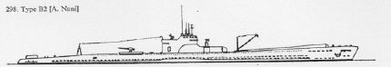
Visit "Which Sub Was It?"
for further discussion on the identity of the first Japanese submarine sunk by
BATFISH |
|
|
Sunk: Japanese Submarine - 1,500 tons (Officially credited as
RO-112 - 525 tons) |
|
Details: Torpedo Attack #4 on 2/11/45 |
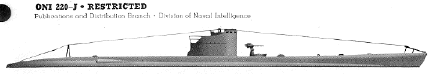 |
|
|
Sunk: Japanese Submarine - 1,500 tons (Officially credited as
RO-113 - 525 tons) |
|
Details: Torpedo Attack #5 on 2/13/45 |
|
|
|
|
|
|
|
|
